
Bo'ness, School Brae Area Of Townscape Character


Town Quarter (Period Unassigned)
Site Name Bo'ness, School Brae Area Of Townscape Character
Classification Town Quarter (Period Unassigned)
Canmore ID 312673
Site Number NS98SE 208
NGR NS 99903 81495
Datum OSGB36 - NGR
Permalink http://canmore.org.uk/site/312673


- Council Falkirk
- Parish Bo'ness And Carriden
- Former Region Central
- Former District Falkirk
- Former County West Lothian
Characterisation (27 November 2013)
This site covers the School Brae Area of Townscape Character which was defined as part of the Bo'ness Urban Survey Project 2013. The text below relates to the whole area.
Historical Development and Topography
School Brae Area of Townscape Character occupies an area immediately south of the town centre, on the north-facing slopes. Stretching up School Brae, it reaches as far west as Church Wynd, encompassing Glebe Park. To the east it takes in The Bog, while its southern boundary runs along Braehead and past Bo’ness Public School, and along the boundaries between housing on the eastern section of Braehead and Stewart Avenue.
One of the earliest buildings in the area is St Mary’s Roman Catholic Church, dating from 1796 with alterations and additions in 1837, and the later 19th century. The church remained in use until 1959, and then fell into disrepair until being restored and converted to flats in 2011 as part of the Bo’ness Townscape Heritage Initiative. The adjacent Liberal Club, dating from 1884 was also part of this restoration and conversion. Designed by Glasgow-based architects John McKissock (c.1844-1915) & William Gardner Rowan (1846-1924), it has served many purposes during the 20th century including a snooker hall (1920s), scout hall (post-WWII), store and upholsterers’ business (late 1960s) before falling into disuse in the late 20th century.
Located on the north-facing slope above the town centre, the area around School Brae’s main period of growth was during the late 19th and early 20th centuries as the burgh spread up the hill. In particular, it seems to have attracted a number of schools to set up in the area during the mid- to late 19th century, including one on Providence Brae, another on School Brae, one adjacent to the Liberal Club, and in the south of the area, the Anderson Academy of 1875, which subsequently became Bo’ness Public School in the early 20th century with later additions. The original St Mary’s Roman Catholic Primary School was also located on the corner of Stewart Avenue and The Bog around 1910, before moving in 1955 to Gauze Road further to the east.
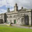
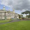
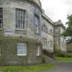
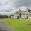
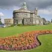
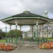
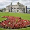
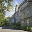
To support the growing population of the town, further facilities were required to service their recreational needs. In 1901, a new Town Hall and Carnegie Library were built within Glebe Park overlooking the town to designs by renowned architect George Washington Browne (1853-1939). The philanthropist Andrew Carnegie (1835-1919) donated half of the £10,000 cost to build the library. A cast-iron octagonal bandstand by Walter McFarlane & Co Saracen Foundry was erected in the park in 1902. In 1909, the Masonic Lodge was built on Stewart Avenue to designs by Matthew Steele (1878-1937) for Lodge Douglas 409.
During the late 19th and early 20th century, a number of semi-detached, single-storeyed-plus-attic villas with bay windows were built on the south side of Stewart Avenue, taking full advantage of the views across the River Forth. The unusual James Thomson-designed (b.1867) Ochil Tower dates from 1903 and stands out from the rest of the street with its battlemented, three-storeyed hexagonal tower on the south-west corner. The rest of the properties in the area from this period are semi-detached or terraced, one-and-a-half- or two-storeyed with full-height bay windows. Matthew Steele designed other properties in the area, including 73–81 Stewart Terrace (1935) and possibly also 87–89 Stewart Terrace, adjacent to the Masonic Lodge, which has a datestone ‘MKS 1909’ on the front elevation.
During the mid- to late 20th century, social housing developed in small pockets in the area, with two four-in-a-blocks on the west side of School Brae and a two-storeyed terrace of flats at 62–66 Stewart Avenue both dating from the 1930s. A slightly larger group of local authority-built two-storeyed terraced houses and three- and four-storeyed flats in Bomar Avenue date from the 1970s. During the 1960s/70s, the area to the west of Providence Brae was developed with private one-and-a-half- and two-storeyed detached housing. There has been little development in the area since this date, apart from a large detached property with crowstepped gables, and a block of three- and four-storeyed flats on St Mary’s Lane on the corner of Stewart Avenue and The Bog.
Present Character
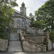
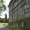
By and large the area has a late 19th/early 20th century character, with the prominent Town Hall of 1901, Bo’ness Public School of 1875 and later, as well as the range of terraced and semi-detached housing dating from this period. The majority of these earlier buildings are stone-built with bay windows. The Town Hall, designed by George Washington Browne, sits in a prominent site overlooking the town, with balustraded parapets, large bowed sections at ground floor level in the eastern section, and small-domed clock-towers with decorative stonework. The cast-iron bandstand in Glebe Park is a good example of the Saracen Foundry’s decorative ironwork, with slim columns surmounted by intricate brackets incorporating a lute motif. The slate roof is topped with a crown.
Matthew Steele’s work is represented in this area, and some claim that his Masonic Lodge on Stewart Avenue is his most interesting work. Built in 1909 of bull-faced sandstone, it is almost Arts and Crafts style in appearance, with low sloping piended roofs and small window openings. The entrance portico is supported by short columns on top of large blocked piers, and a triangular pedimented gable is inscribed with Masonic symbols and ‘409 Lodge Douglas’. The building is in contrast to the later example of his work just west of the Lodge – local authority four-in-a-block housing (1935) at 73–81 Stewart Avenue, with strong horizontal banding in the central block, and relatively plain harling.
The area has a fairly low density, with medium to large plot sizes, particularly with the larger public buildings and Glebe Park in the centre of the area. There is one main road, Stewart Avenue, leading through the area, with connecting routes leading north-south being smaller in scale. Development has followed the topography of the slope, with the earlier buildings built facing north, overlooking the town centre and over the River Forth. Late 20th century infilling on the north side of Stewart Avenue at School Brae has been built into the slope to allow this view to be retained by those on the south side of the street.
Information from RCAHMS (LK), 27th November 2013

