 |
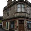
On-line Digital Images |
DP 103745 |
Records of the Royal Commission on the Ancient and Historical Monuments of Scotland (RCAHMS), Edinbu |
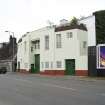
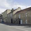
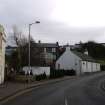
General street view showing 17 Corbiehall, Bo'ness, taken from the West. This photograph was taken as part of the Bo'ness Urban Survey to illustrate the character of the Corbiehall and Snab Area of Townscape Character. |
17/8/2011 |
Item Level |
|
 |
On-line Digital Images |
DP 103746 |
Records of the Royal Commission on the Ancient and Historical Monuments of Scotland (RCAHMS), Edinbu |
General street view showing 1-15 Corbiehall, Bo'ness, taken from the South-West. This photograph was taken as part of the Bo'ness Urban Survey to illustrate the character of the Corbiehall and Snab Area of Townscape Character. |
17/8/2011 |
Item Level |
|
 |
On-line Digital Images |
DP 105649 |
Records of the Royal Commission on the Ancient and Historical Monuments of Scotland (RCAHMS), Edinbu |
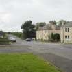
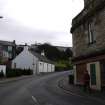
Street view showing the junction of Snab Lane and Grangemouth Road, Bo'ness, taken from the South-East looking towards 1 and 2 Snab Lane. This photograph was taken as part of the Bo'ness Urban Survey to illustrate the character of the Corbiehall and Snab Area of Townscape Character. |
20/9/2011 |
Item Level |
|
 |
On-line Digital Images |
DP 105650 |
Records of the Royal Commission on the Ancient and Historical Monuments of Scotland (RCAHMS), Edinbu |
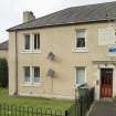
View of 1 Snab Lane, Bo'ness, taken from the South-East. The image shows the building's datestone, which reads 'BTC 1934' (Bo'ness Town Council). This photograph was taken as part of the Bo'ness Urban Survey to illustrate the character of the Corbiehall and Snab Area of Townscape Character. |
20/9/2011 |
Item Level |
|
 |
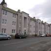
On-line Digital Images |
DP 105651 |
Records of the Royal Commission on the Ancient and Historical Monuments of Scotland (RCAHMS), Edinbu |
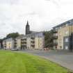
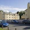
Street view showing three modern apartment blocks at 207-213 Corbiehall, Bo'ness, taken from the North-West. This photograph was taken as part of the Bo'ness Urban Survey to illustrate the character of the Corbiehall and Snab Area of Townscape Character. |
20/9/2011 |
Item Level |
|
 |
On-line Digital Images |
DP 105652 |
Records of the Royal Commission on the Ancient and Historical Monuments of Scotland (RCAHMS), Edinbu |
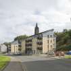
Street view showing three modern apartment blocks at 207-213 Corbiehall, Bo'ness, taken from the North-West. This photograph was taken as part of the Bo'ness Urban Survey to illustrate the character of the Corbiehall and Snab Area of Townscape Character. |
20/9/2011 |
Item Level |
|
 |
On-line Digital Images |
DP 105653 |
Records of the Royal Commission on the Ancient and Historical Monuments of Scotland (RCAHMS), Edinbu |
View of 101 and 103 Corbiehall, Bo'ness, taken from the North-West. This photograph was taken as part of the Bo'ness Urban Survey to illustrate the character of the Corbiehall and Snab Area of Townscape Character. |
20/9/2011 |
Item Level |
|
 |
On-line Digital Images |
DP 105654 |
Records of the Royal Commission on the Ancient and Historical Monuments of Scotland (RCAHMS), Edinbu |
Street view showing 97-103 Corbiehall, Bo'ness, taken from the North-West. This photograph was taken as part of the Bo'ness Urban Survey to illustrate the character of the Corbiehall and Snab Area of Townscape Character. |
20/9/2011 |
Item Level |
|
 |
On-line Digital Images |
DP 105655 |
Records of the Royal Commission on the Ancient and Historical Monuments of Scotland (RCAHMS), Edinbu |
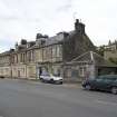
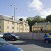
General street view showing the Southern side of Corbiehall (Nos 65-103), Bo'ness, taken from the North-West. This photograph was taken as part of the Bo'ness Urban Survey to illustrate the character of the Corbiehall and Snab Area of Townscape Character. |
20/9/2011 |
Item Level |
|
 |
On-line Digital Images |
DP 105656 |
Records of the Royal Commission on the Ancient and Historical Monuments of Scotland (RCAHMS), Edinbu |
View of 20th century council housing, designed by Matthew Steele, at 43-51 Corbiehall, Bo'ness, taken from the North-West. This photograph was taken as part of the Bo'ness Urban Survey to illustrate the character of the Corbiehall and Snab Area of Townscape Character. |
20/9/2011 |
Item Level |
|
 |
On-line Digital Images |
DP 105657 |
Records of the Royal Commission on the Ancient and Historical Monuments of Scotland (RCAHMS), Edinbu |
View of 20th century council housing, designed by Matthew Steele, at 43-51 Corbiehall, Bo'ness, taken from the North-West. This photograph was taken as part of the Bo'ness Urban Survey to illustrate the character of the Corbiehall and Snab Area of Townscape Character. |
20/9/2011 |
Item Level |
|
 |
On-line Digital Images |
DP 105658 |
Records of the Royal Commission on the Ancient and Historical Monuments of Scotland (RCAHMS), Edinbu |
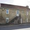
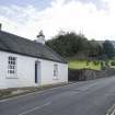
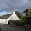
Street view showing 19th century cottage at 19 Church Wynd, Bo'ness, taken from the North-West. The burial ground of Bo'ness Parish Church, dating from the 17th century, can also be seen in this image. This photograph was taken as part of the Bo'ness Urban Survey to illustrate the character of the Corbiehall and Snab Area of Townscape Character. |
20/9/2011 |
Item Level |
|
 |
On-line Digital Images |
DP 105659 |
Records of the Royal Commission on the Ancient and Historical Monuments of Scotland (RCAHMS), Edinbu |
Street view showing 15, 17 and 19 Church Wynd, Bo'ness, taken from the North-West. The burial ground of Bo'ness Parish Church, dating from the 17th century, can also be seen in this image. This photograph was taken as part of the Bo'ness Urban Survey to illustrate the character of the Corbiehall and Snab Area of Townscape Character. |
20/9/2011 |
Item Level |
|
 |
On-line Digital Images |
DP 105660 |
Records of the Royal Commission on the Ancient and Historical Monuments of Scotland (RCAHMS), Edinbu |
View of 8-14 Corbiehall, Bo'ness, taken from the North-East. This photograph was taken as part of the Bo'ness Urban Survey to illustrate the character of the Corbiehall and Snab Area of Townscape Character. |
20/9/2011 |
Item Level |
|
 |
On-line Digital Images |
DP 105661 |
Records of the Royal Commission on the Ancient and Historical Monuments of Scotland (RCAHMS), Edinbu |
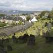
General street view showing Church Wynd, Bo'ness, taken from Bo'ness Parish Churchyard to the South-West. This photograph was taken as part of the Bo'ness Urban Survey to illustrate the character of the Corbiehall and Snab Area of Townscape Character. |
20/9/2011 |
Item Level |
|
 |
On-line Digital Images |
DP 105662 |
Records of the Royal Commission on the Ancient and Historical Monuments of Scotland (RCAHMS), Edinbu |
General street view showing Church Wynd, Bo'ness, taken from Bo'ness Parish Churchyard to the South-West. This photograph was taken as part of the Bo'ness Urban Survey to illustrate the character of the Corbiehall and Snab Area of Townscape Character. |
20/9/2011 |
Item Level |
|
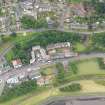 |
On-line Digital Images |
DP 321164 |
Records of the Royal Commission on the Ancient and Historical Monuments of Scotland (RCAHMS), Edinbu |
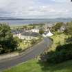
General oblique aerial view showing Corbiehall, Bo'ness, taken from NW. |
28/7/2011 |
Item Level |
|
 |
On-line Digital Images |
DP 322093 |
Records of the Royal Commission on the Ancient and Historical Monuments of Scotland (RCAHMS), Edinbu |
View from north showing Nos 1-5 Corbiehall, Bo'ness. |
24/1/2011 |
Item Level |
|
 |
On-line Digital Images |
DP 322094 |
Records of the Royal Commission on the Ancient and Historical Monuments of Scotland (RCAHMS), Edinbu |
View from north-east showing Nos 191-199 Corbiehall, Bo'ness. |
24/1/2011 |
Item Level |
|
 |
On-line Digital Images |
DP 322095 |
Records of the Royal Commission on the Ancient and Historical Monuments of Scotland (RCAHMS), Edinbu |
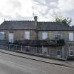
View from south-west showing Nos 46-48 Corbiehall, Bo'ness. |
24/1/2011 |
Item Level |
|
 |
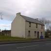
On-line Digital Images |
DP 322108 |
Records of the Royal Commission on the Ancient and Historical Monuments of Scotland (RCAHMS), Edinbu |
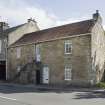
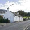
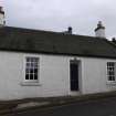
View from north-west showing No 19 Church Wynd, Bo'ness. |
24/1/2011 |
Item Level |
|
 |
On-line Digital Images |
DP 322109 |
Records of the Royal Commission on the Ancient and Historical Monuments of Scotland (RCAHMS), Edinbu |
View from west showing No 19 Church Wynd, Bo'ness. |
24/1/2011 |
Item Level |
|
 |
On-line Digital Images |
DP 322110 |
Records of the Royal Commission on the Ancient and Historical Monuments of Scotland (RCAHMS), Edinbu |
View from south showing No 19 Church Wynd, Bo'ness. |
24/1/2011 |
Item Level |
|
 |
On-line Digital Images |
DP 322111 |
Records of the Royal Commission on the Ancient and Historical Monuments of Scotland (RCAHMS), Edinbu |
View from north-west showing No 19 Church Wynd, Bo'ness. |
24/1/2011 |
Item Level |
|


