
Bo'ness, Braehead And The Knowe Area Of Townscape Character


Town Quarter (Period Unassigned)
Site Name Bo'ness, Braehead And The Knowe Area Of Townscape Character
Classification Town Quarter (Period Unassigned)
Canmore ID 312669
Site Number NS98SE 214
NGR NS 99608 81273
Datum OSGB36 - NGR
Permalink http://canmore.org.uk/site/312669


- Council Falkirk
- Parish Bo'ness And Carriden
- Former Region Central
- Former District Falkirk
- Former County West Lothian
Characterisation (18 November 2013)
This site covers the Braehead and The Knowe Area of Townscape Character which was defined as part of the Bo'ness Urban Survey Project 2013. The text below relates to the whole area.
Historical Development and Topography
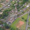
Braehead and the Knowe area is a narrow strip on the top of the bluff or hill above and to the south of the town centre stretching east along from the length of Grange Terrace and Braehead. It ends with Corbiehall and the cemetery at the western extremity. The location affords spectacular views over the town and the Forth valley.
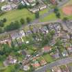
This area was developed in the later 19th century with a series of villas and churches. The villas of Grange Terrace, in a mixture of styles, mostly built of stone under slate roofs set within large gardens characterise the earliest phase of the development of this area. A larger example of one of these villas is the Knowe, Erngarth Road, of 1879, which was extended by Matthew Steele (1878-1937) between 1907 and 1912. Another example of this Edwardian phase of development is the Arts and Crafts style Tidings Hill, which lies further west in Cadzow Crescent, designed by Alexander Hunter Crawford (1865-1945) in 1908.
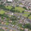
Four of Bo’ness’s six churches are located in this area. The Gothic Craigmailen United Free Church on Braehead is the earliest of the four, dating from 1883 to designs by architects by John McKissack (c.1844-1915) & William Gardner Rowan (1846-1924). Its tall tower, topped by a crown spire, is a prominent landmark on the Bo’ness skyline. The Old Kirk on Panbrae Road was designed by Robert Thornton Shiells (1833-1902) & James M Thomson (c.1850-c.1922) in 1885, also in Gothic style, with a large four-stage tower and spire. St Andrew’s Parish Church of 1905 by John Nichol Scott (1863-1920) & Alexander Lorne Campbell lies to the east on Grange Terrace, and its narrow green copper spire on a three-stage square battlemented tower is similarly dominant. The single-storeyed St Catherine’s Episcopal Church designed in 1921 by John More Dick Peddie (1853-1921) & William James Walker Todd (1884-1944) is in keeping with the interwar harled bungalows surrounding it in Cadzow Crescent.
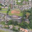
The street pattern in the area is characterised by a wide open arrangement of villas set in large gardens. Braehead and Grange Terrace are further characterised by only being developed on the south side embracing the views over the river to the north. There are large areas of green open space in this area, with Victoria Park on the north side of Grange Terrace and the large cemetery to the west of the area. This openness is enhanced with Braehead overlooking Glebe Park and the Town Hall which lie within the School Brae Area of Townscape Character). Overall the area is uniformly low density with a variety of plot sizes some of which are very large.
Present Character
The area has changed little since it was developed in the later 19th century and early to mid-20th century. It remains almost totally residential, though some of the larger villas have been sub-divided. Mostly stone-built, these villas have retained much of their Victorian or Edwardian characteristics, including large bay windows affording views across the river, as well as retaining the large garden plots.
Still a mainly residential area, Braehead and The Knowe has retained associated facilities for its resident population, including the four churches (Craigmailen United Free Church, the Old Kirk, St Andrew’s Parish Church and St Catherine’s Episcopal Church), Grange School on Grange Loan (1906), green space in Victoria Park, bowling green and the cemetery. Many other facilities lie just outwith the area such as the hospital in Dean Road (Newtoun Area of Townscape Character), with the main town centre being easily accessible.
There has been little infilling within this area since the initial development in the late 19th and early 20th century. A small pocket of infill dating from the 1920s is Cadzow Crescent, which consists of single-storeyed bungalows, in a style typical of the period.
Information from RCAHMS (LK), 18th November 2013

