Accessibility

Font Size

100% 150% 200%

Background Colour

Default Contrast
Close Reset

Bo'ness, Kinneil Area Of Townscape Character

Town Quarter (Period Unassigned)

Site Name Bo'ness, Kinneil Area Of Townscape Character

Classification Town Quarter (Period Unassigned)

Canmore ID 312664

Site Number NS98SE 204

NGR NS 98886 80093

Datum OSGB36 - NGR

Permalink http://canmore.org.uk/site/312664

Ordnance Survey licence number AC0000807262. All rights reserved.
Canmore Disclaimer. © Bluesky International Limited 2025. Public Sector Viewing Terms

Toggle Aerial | View on large map

Digital Images

Detail view of the entrance door to the centre of the East (principal) elevation of Kinneil House, Bo'ness, taken from the East. This photograph was taken as part of the Bo'ness Urban Survey to illustrate the character of the Kinneil Area of Townscape Character.
Detail view of the entrance door to the centre of the East (principal) elevation of Kinneil House, Bo'ness, taken from the East. This photograph was taken as part of the Bo'ness Urban Survey to illustrate the character of the Kinneil Area of Townscape Character.Street view showing 2-8 Woodlands Drive, Bo'ness, taken from the North-East. This photograph was taken as part of the Bo'ness Urban Survey to illustrate the character of the Kinneil Area of Townscape Character.Street view showing Woodlands Drive, Bo'ness, taken from the North. This photograph was taken as part of the Bo'ness Urban Survey to illustrate the character of the Kinneil Area of Townscape Character.Street view showing detached housing arranged around a circle at 43-47 Green Tree Lane, Bo'ness. This photograph was taken as part of the Bo'ness Urban Survey to illustrate the character of the Kinneil Area of Townscape Character.Elevated street view showing Blair Avenue, Bo'ness, taken from the South. This photograph was taken as part of the Bo'ness Urban Survey to illustrate the character of the Kinneil Area of Townscape Character.Street view showing housing at Blair Avenue, Bo'ness, taken across the central green space. This photograph was taken as part of the Bo'ness Urban Survey to illustrate the character of the Kinneil Area of Townscape Character.Street view showing housing at Blair Avenue, Bo'ness, taken across the central green space. This photograph was taken as part of the Bo'ness Urban Survey to illustrate the character of the Kinneil Area of Townscape Character.View of the gate piers to Kinneil House, Bo'ness, taken from the North-East. This photograph was taken as part of the Bo'ness Urban Survey to illustrate the character of the Kinneil Area of Townscape Character.Detailed view of the lower section of the Western wall of Kinneil House, Bo'ness, taken from the North-West. This photograph was taken as part of the Bo'ness Urban Survey to illustrate the character of the Kinneil Area of Townscape Character.View of the North wing of Kinneil House, Bo'ness, taken from the North. This photograph was taken as part of the Bo'ness Urban Survey to illustrate the character of the Kinneil Area of Townscape Character.General view showing 2-5 Duchess Anne Cottages, Kinneil Estate, Bo'ness, taken from the South. This photograph was taken as part of the Bo'ness Urban Survey to illustrate the character of the Kinneil Area of Townscape Character.General oblique aerial view of Kinneil area of Bo'ness, taken from the WSW.General view of Kinneil House, Bo'ness, taken from the East. This photograph was taken as part of the Bo'ness Urban Survey to illustrate the character of the Kinneil Area of Townscape Character.General street view showing 25-31 Chesnut Grove, Bo'ness, taken from the North. This photograph was taken as part of the Bo'ness Urban Survey to illustrate the character of the Kinneil Area of Townscape Character.Street view showing 1-11 Willow Dell, Bo'ness, taken from the North-West. This photograph was taken as part of the Bo'ness Urban Survey to illustrate the character of the Kinneil Area of Townscape Character.Elevated street view showing Blair Avenue, Bo'ness, taken from the South-West. This photograph was taken as part of the Bo'ness Urban Survey to illustrate the character of the Kinneil Area of Townscape Character.Oblique aerial view of Kinneil House and Duchess Anne Cottages, Bo'ness, taken from the SSE.Oblique aerial view of Kinneil House and Duchess Anne Cottages, Bo'ness, taken from the SE.View of the North wing of Kinneil House, taken from the South-East. This photograph was taken as part of the Bo'ness Urban Survey to illustrate the character of the Kinneil Area of Townscape Character.General view of James Watt's Cottage, Kinneil, Bo'ness, taken from the North-East. This remains of this small building are situated to the South-West of Kinneil House. This photograph was taken as part of the Bo'ness Urban Survey to illustrate the character of the Kinneil Area of Townscape Character.View of 2-4 Duchess Anne Cottages, Kinneil Estate, Bo'ness, taken from the South. This photograph was taken as part of the Bo'ness Urban Survey to illustrate the character of the Kinneil Area of Townscape Character.Street view showing 25-31 Chesnut Grove, Bo'ness, taken from the North. A Citreon 'Dolly' car is in the foreground, parked in the central area of parking and green space. This photograph was taken as part of the Bo'ness Urban Survey to illustrate the character of the Kinneil Area of Townscape Character.General oblique aerial view of Kinneil area of Bo'ness, taken from the SSW.Oblique aerial view of Kinneil House and Duchess Anne Cottages, Bo'ness, taken from the WSW.Street view showing detached housing at Blair Avenue, Bo'ness, taken across the central green space. This photograph was taken as part of the Bo'ness Urban Survey to illustrate the character of the Kinneil Area of Townscape Character.General oblique aerial view of Kinneil area of Bo'ness, taken from the NE.General oblique aerial view of Kinneil area of Bo'ness, taken from the NW.General oblique aerial view of the Kinneil area of Bo'ness, taken from the NW.View of the East elevation of Kinneil House, Bo'ness, taken from the East. This photograph was taken as part of the Bo'ness Urban Survey to illustrate the character of the Kinneil Area of Townscape Character.View of the North wing of Kinneil House, taken from the South. This photograph was taken as part of the Bo'ness Urban Survey to illustrate the character of the Kinneil Area of Townscape Character.VIew of 6-8 Duchess Anne Cottages, Kinneil Estate, Bo'ness, taken from the North-East. This photograph was taken as part of the Bo'ness Urban Survey to illustrate the character of the Kinneil Area of Townscape Character.View looking towards Kinneil House and gate piers, Bo'ness, taken from Duchess Anne Cottages to the North-East. This photograph was taken as part of the Bo'ness Urban Survey to illustrate the character of the Kinneil Area of Townscape Character.View of 2-4 Duchess Anne Cottages, Kinneil Estate, Bo'ness, taken from the North-West. This photograph was taken as part of the Bo'ness Urban Survey to illustrate the character of the Kinneil Area of Townscape Character.General street view of the Western end of Chesnut Grove, Bo'ness. The image shows the housing arranged around a central landscaped area, which also includes residents' parking. This photograph was taken as part of the Bo'ness Urban Survey to illustrate the character of the Kinneil Area of Townscape Character.View of semi-detached housing at 52-54 Chesnut Grove, Bo'ness, taken from the North. This image also shows the residents' central green space and car parking. This photograph was taken as part of the Bo'ness Urban Survey to illustrate the character of the Kinneil Area of Townscape Character.View of semi-detached housing at 30-36 Chesnut Grove, Bo'ness, taken from the South. This image also shows the residents' central green space and car parking. This photograph was taken as part of the Bo'ness Urban Survey to illustrate the character of the Kinneil Area of Townscape Character.Street view showing 16 Hazeldean Avenue, Bo'ness, taken from the North-West. This photograph was taken as part of the Bo'ness Urban Survey to illustrate the character of the Kinneil Area of Townscape Character.Street view showing 11-18 Hazeldean Avenue, Bo'ness, taken from the South. This photograph was taken as part of the Bo'ness Urban Survey to illustrate the character of the Kinneil Area of Townscape Character.View of detached housing at 19 and 20 Hazeldean Avenue, Bo'ness, taken from the South-West. This photograph was taken as part of the Bo'ness Urban Survey to illustrate the character of the Kinneil Area of Townscape Character.View of the detached housing arranged around a circle at Green Tree Lane, Bo'ness. This image shows Nos 53 and 55 Green Tree Lane, taken from the East. This photograph was taken as part of the Bo'ness Urban Survey to illustrate the character of the Kinneil Area of Townscape Character.Oblique aerial view of Kinneil House and Duchess Anne Cottages, Bo'ness, taken from the ENE.View of the South elevation of Kinneil House, Bo'ness. The North wing is visible in the background. This photograph was taken as part of the Bo'ness Urban Survey to illustrate the character of the Kinneil Area of Townscape Character.View of the West elevation of the North wing to Kinneil House, Bo'ness, taken from the South-West. This photograph was taken as part of the Bo'ness Urban Survey to illustrate the character of the Kinneil Area of Townscape Character.View of 12 Hazeldean Avenue, Bo'ness, taken from the North-East. This photograph was taken as part of the Bo'ness Urban Survey to illustrate the character of the Kinneil Area of Townscape Character.Street view looking East up Hazeldean Avenue, Bo'ness, with 18 Hazeldean Avenue in the foreground to the left of the shot. This photograph was taken as part of the Bo'ness Urban Survey to illustrate the character of the Kinneil Area of Townscape Character.General view of Kinneil House, Bo'ness, taken from the South-East. This photograph was taken as part of the Bo'ness Urban Survey to illustrate the character of the Kinneil Area of Townscape Character.View of 2-4 Duchess Anne Cottages, Kinneil Estate, Bo'ness, taken from the South-West. This photograph was taken as part of the Bo'ness Urban Survey to illustrate the character of the Kinneil Area of Townscape Character.Street view showing 6-16 Willow Dell, Bo'ness, taken across the garden of 18 Willow Dell to the North-West. This photograph was taken as part of the Bo'ness Urban Survey to illustrate the character of the Kinneil Area of Townscape Character.General oblique aerial view of Kinneil area of Bo'ness, taken from the NNW.General oblique aerial view of Kinneil area of Bo'ness, taken from the WNW.Oblique aerial view of Kinneil House and Duchess Anne Cottages, Bo'ness, taken from the SW.Oblique aerial view of Kinneil House and Duchess Anne Cottages, Bo'ness, taken from the ESE.

Administrative Areas

  • Council Falkirk
  • Parish Bo'ness And Carriden
  • Former Region Central
  • Former District Falkirk
  • Former County West Lothian

Activities

Characterisation (16 December 2013)

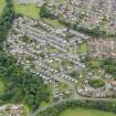
This site covers the Kinneil Area of Townscape Character which was defined as part of the Bo'ness Urban Survey Project 2013. The text below relates to the whole area.

Historical Development and Topography

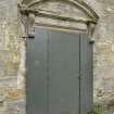
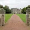
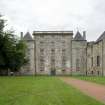
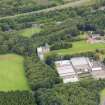
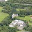
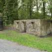
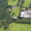
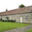
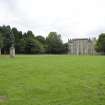
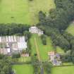
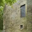
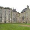
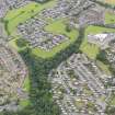
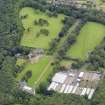
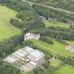
Kinneil Area of Townscape Character lies on the western edge of Bo’ness and includes the oldest building in the area, Kinneil House, with its origins in the 15th century. Several additions and remodelling were carried out on the house during the 16th and 17th centuries, which lies within extensive parkland with associated woodland and other ancillary buildings still surviving in the vicinity. The axial approach to the 17th century palace front of Kinneil is the strongest element of designed landscape within the area. Nearby is the walled garden along with various rubble-built cottages and estate buildings of 18th and 19th century date. The ruins of one of the estate buildings is recognised as being the cottage and workshop where James Watt (1736-1819) and Dr John Roebuck (1718-94), the then owner of Kinneil House and founder of the Carron Iron Works in Falkirk, began working on improved steam engines to pump water from Roebuck’s nearby pits. When Roebuck became bankrupt in 1773, Watt continued his work with Matthew Boulton of Birmingham (1728-1809) and the improved steam engine design was perfected. This group of buildings forms a distinct character area of its own forming the northern third of the area.

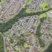
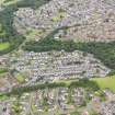
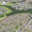
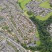
The area remained virtually undeveloped until the post-WWII era when several private housing schemes were built from c.1950 to the present day. The main public building in the area is the local primary school, Deanburn Primary School, which was originally built in the early 1970s, during a time of expansion in the area. The school was badly damaged by fire in 2002, and a new school was built in 2004-5. This forms the most recent development in the area.

Present Character

Kinneil House is the main landmark building in this area, with its origins in the late 15th century. The original two-storeyed-plus-basement tower house (the north section of the house now partly ruinous) was extended and remodelled to the south in the 16th and 17th centuries, with the addition of a ‘palace’ range c. 1553-5. This has a five-storeyed, three-bayed, balustraded central section with slightly projecting four-storeyed towers with pyramidal roofs. The interior contains several 16th century painted wall and ceiling decorations, the discovery of which saved the building from demolition in the late 1930s.

The area around Kinneil House is characterised by the axial approach drive and a pattern of estate roads. The rest of the area consists of residential developments on curving roads and cul-de-sacs within the peripheral Crawfield Road and Provost Road which enclose the area on its western boundary. There are large open spaces within the layout of the southern part of Kinneil, which gives the area a slightly more open feel, despite the fairly high density of development.

Apart from the earlier buildings of the Kinneil Estate dating from 15th to 19th centuries the area is predominantly brick and roughcast with tiled or slated roofs. The late 20th century developments consist of terraced and detached houses or bungalows within medium-sized garden plots typical of the period. The design of the houses is very plain, with the use of mixed materials (brick, harling and timber panelling) on some of the earlier developments being the main characteristic features. Many of the detached houses from the 1960s and 1970s have steep gables to the upper floors, but most are simple two-storeyed designs.

Information from RCAHMS (LK), 16th December 2013

References

MyCanmore Image Contributions


Contribute an Image

MyCanmore Text Contributions