
Bo'ness, Gauze Road Area Of Townscape Character


Town Quarter (Period Unassigned)
Site Name Bo'ness, Gauze Road Area Of Townscape Character
Classification Town Quarter (Period Unassigned)
Canmore ID 312656
Site Number NT08SW 164
NGR NT 00413 80762
Datum OSGB36 - NGR
Permalink http://canmore.org.uk/site/312656


- Council Falkirk
- Parish Bo'ness And Carriden
- Former Region Central
- Former District Falkirk
- Former County West Lothian
Characterisation (26 November 2013)
This site covers the Gauze Road Area of Townscape Character which was defined as part of the Bo'ness Urban Survey Project 2013. The text below relates to the whole area.
Historical Development and Topography
The Gauze Road Area of Townscape Character contains the site of perhaps the earliest occupation of the area now called Bo’ness, a Roman camp associated with the Antonine Wall lying just east of St Mary’s Primary School and partly in Kinglass Park.
The Gauze Road Area of Townscape Character had little development since these early origins, apart from one or two 19th century single-storeyed cottages to the south of Gauze Road, backing onto Gauze Court, and the 19th century farmhouse of Kinglass Farm in the far south.
Much of the area’s growth has been in the late 20th and early 21st century. The beginnings of this came in 1931 when the original Bo’ness Academy was built in Academy Road in the north of the area. This was extended in the late 1950s and again in 1971 by Alison & Hutchison & Partners on its original site. In 1955, St Mary’s Roman Catholic Primary School was also built to designs by Alison & Hutchison & Partners to the west of this. The open land to the south of both schools served as playing fields and general recreation area for the town, and the town’s recreation centre and swimming pool was built here in 1972, again designed by Alison & Hutchison & Partners.
A new Academy building was designed and built on Gauze Road 1998-2000 by The Parr Partnership, and the old Academy buildings in Academy Road were demolished. The land previously occupied by the Academy was subsequently infilled with a suburban private residential estate in the late 1990s and early 2000s. Similar infilling occurred at the southern edge of the playing fields, surrounding the 19th century Kinglass Farmhouse.
Present Character
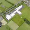
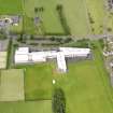
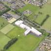
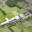
Gauze Road has a very open feeling due to the large expanse of playing fields associated with the schools and recreation centre in the area. Development has been kept to the edges of the area, and has only occurred following the building of the new Bo’ness Academy to designs by The Parr Partnership from 1998 to 2000. The school is a large three-storeyed, T-plan building with a shallow pitched corrugated metal roof and incorporating a mixture of brick, harling and metal in its design.
The northern and southern edges of the area are composed of residential streets and cul-de-sacs, comprising two-storeyed houses with a mixture of red and yellow brick or artificial stone facings and harling, with tiled or pantiled roofs. In the northern corner, there is also a group of red brick terraced houses on Grahamsdyke Place which overlook the playing fields. The houses in the far north-west corner at the entrance to the Craigallan Park scheme have stone facings and stone boundary walls in keeping with the 19th century villas on Grahamsdyke Road.
Information from RCAHMS (LK), 26th November 2013

