Accessibility

Font Size

100% 150% 200%

Background Colour

Default Contrast
Close Reset

Bo'ness, Town Centre Area Of Townscape Character

Town Quarter (Period Unassigned)

Site Name Bo'ness, Town Centre Area Of Townscape Character

Classification Town Quarter (Period Unassigned)

Canmore ID 312536

Site Number NS98SE 201

NGR NS 99908 81737

Datum OSGB36 - NGR

Permalink http://canmore.org.uk/site/312536

Ordnance Survey licence number AC0000807262. All rights reserved.
Canmore Disclaimer. © Bluesky International Limited 2025. Public Sector Viewing Terms

Toggle Aerial | View on large map

Digital Images

View looking down Scotland's Close, Bo'ness, taken from the South-West. Dymock's Buildings can be seen to the right of the image. This photograph was taken as part of the Bo'ness Urban Survey to illustrate the character of the Town Centre Area of Townscape Character.
View looking down Scotland's Close, Bo'ness, taken from the South-West. Dymock's Buildings can be seen to the right of the image. This photograph was taken as part of the Bo'ness Urban Survey to illustrate the character of the Town Centre Area of Townscape Character.View of Corvi's cafe and fish and chip shop, 5-7 Seaview Place, Bo'ness, taken from the North-West. This photograph was taken as part of the Bo'ness Urban Survey to illustrate the character of the Town Centre Area of Townscape Character.General street view showing 1-17 South Street, Bo'ness, taken from the South-West. This photograph was taken as part of the Bo'ness Urban Survey to illustrate the character of the Town Centre Area of Townscape Character.View of 64-70 South Street, Bo'ness, taken from the North-East.  This photograph was taken as part of the Bo'ness Urban Survey to illustrate the character of the Town Centre Area of Townscape Character.General street view showing 62-70 South Street, Bo'ness, taken from the North-West. This photograph was taken as part of the Bo'ness Urban Survey to illustrate the character of the Town Centre Area of Townscape Character.General street view showing 24-34 South Street, Bo'ness, taken from the North-West. This photograph was taken as part of the Bo'ness Urban Survey to illustrate the character of the Town Centre Area of Townscape Character.Street view showing buildings at 13-23 Waggon Road (the rear of North Street), Bo'ness, taken from the North-West. This photograph was taken as part of the Bo'ness Urban Survey to illustrate the character of the Town Centre Area of Townscape Character.General view showing Waggon Road and the rear of 31-35 North Street and 37-49 Scotland's Close, Bo'ness, taken from the North-West. This photograph was taken as part of the Bo'ness Urban Survey to illustrate the character of the Town Centre Area of Townscape Character.General view showing Bo'ness Library, Scotland's Close and the North-Western edge of Dymock's buildings, taken from the North-East. This photograph was taken as part of the Bo'ness Urban Survey to illustrate the character of the Town Centre Area of Townscape Character.Street view showing 45-51 North Street (Dymock's Building), Bo'ness, taken from the South-East. This photograph was taken as part of the Bo'ness Urban Survey to illustrate the character of the Town Centre Area of Townscape Character.General street view showing Bo'ness bus stance and buildings on the Western side of East Pier Street, taken from the North-West. This photograph was taken as part of the Bo'ness Urban Survey to illustrate the character of the Town Centre Area of Townscape Character.General street view showing Bo'ness Market Square, North Street, taken from the North (from the junction with East Pier Street). This photograph was taken as part of the Bo'ness Urban Survey to illustrate the character of the Town Centre Area of Townscape Character.View from south-west showing Seaview Place, Bo'ness, from No 11 Seaview Place.View from north-west showing rear (North Street) elevation of Nos 5-11 South Street, Bo'ness.View from south-east showing shop fronts at Anderson Building, Nos 23-29 South Street, Bo'ness.Detail of entrance block at No 11 Seaview Place, Bo'ness.Detail of decorative ironwork screens on window at No 28 South Street, Bo'ness.View from south-west showing Scotland's Close elevation of Warehouse (Dymock's Buildings), 45-51 North Street, Bo'ness.General street view showing 1-13 South Street, Bo'ness, taken from the South-East. This photograph was taken as part of the Bo'ness Urban Survey to illustrate the character of the Town Centre Area of Townscape Character.View of 2-10 High Street, Bo'ness, taken from the North West. This photograph was taken as part of the Bo'ness Urban Survey to illustrate the character of the Town Centre Area of Townscape Character.Street view looking towards 31-35 Scotland's Close and 37-43 North Street, Bo'ness, taken from the South-West. This photograph was taken as part of the Bo'ness Urban Survey to illustrate the character of the Town Centre Area of Townscape Character.View of Scotland's Close, Bo'ness, taken from the North-East, showing Dymock's buildings. This photograph was taken as part of the Bo'ness Urban Survey to illustrate the character of the Town Centre Area of Townscape Character.Street view showing the Art Deco cube building at 126 North Street, Bo'ness, taken from the North-East. 72-80 South Street can be seen in the background. This photograph was taken as part of the Bo'ness Urban Survey to illustrate the character of the Town Centre Area of Townscape Character.General street view showing Bo'ness bus stance and buildings on the Western side of East Pier Street, taken from the North-West. This photograph was taken as part of the Bo'ness Urban Survey to illustrate the character of the Town Centre Area of Townscape Character.General street view showing Bo'ness bus stance and buildings on the Western side of East Pier Street, taken from the North-West. This photograph was taken as part of the Bo'ness Urban Survey to illustrate the character of the Town Centre Area of Townscape Character.View from south-west showing site of former Seaview Ironworks, Commissioners Street, Bo'ness.View from west showing Nos 1-3 Main Street, Bo'ness.General view from west showing supermarkets on Main Street, Bo'ness.View from north-east showing rear elevation of supermarket on Main Street, Bo'ness.View from north-east showing Former Foundry Offices, Nos 58-62 Union Street, Bo'ness.View from north-east showing Bo'ness Library (former West Pier Tavern), Scotland's Close, Bo'ness.View from south showing Nos 43-45 South Street, Bo'ness.View from south-west showing Burgh Chambers, No 15 Seaview Place, Bo'ness.View from north showing The Carriers Quarters, Nos 8-10 Main Street, Bo'ness.General street view showing 2-8 Hope Street and 19-33 South Street, Bo'ness, taken from the South-West. This photograph was taken as part of the Bo'ness Urban Survey to illustrate the character of the Town Centre Area of Townscape Character.General street view showing 15-29 North Street, Bo'ness, taken from the East. This photograph was taken as part of the Bo'ness Urban Survey to illustrate the character of the Town Centre Area of Townscape Character.Street view showing 42-54 North Street, Bo'ness, taken from the North-West. The Hippodrome on Hope Street can also be seen to the right of the image.  This photograph was taken as part of the Bo'ness Urban Survey to illustrate the character of the Town Centre Area of Townscape Character.View towards 37-43 North Street, Bo'ness, taken from the East. This photograph was taken as part of the Bo'ness Urban Survey to illustrate the character of the Town Centre Area of Townscape Character.General view showing Waggon Road, Bo'ness Library and the rear of 37-49 Scotland's Close,  taken from the North. This photograph was taken as part of the Bo'ness Urban Survey to illustrate the character of the Town Centre Area of Townscape Character.Street view showing 42-46 and 50-54 North Street, Bo'ness, taken from the North. This photograph was taken as part of the Bo'ness Urban Survey to illustrate the character of the Town Centre Area of Townscape Character.View looking towards Bo'ness bus stance, taken from the South, with the corner of 67 North Street to the right of the shot. This photograph was taken as part of the Bo'ness Urban Survey to illustrate the character of the Town Centre Area of Townscape Character.Street view showing Custom House at 14-20 Union Street, Bo'ness, taken from the North. This photograph was taken as part of the Bo'ness Urban Survey to illustrate the character of the Town Centre Area of Townscape Character.General oblique aerial view of Bo'ness town centre, taken from the SSE.View from west showing Nos 95-135 North Street, Bo'ness.View from north-east showing No 18 South Street, and Station Hotel, Nos 1-3 Seaview Place, Bo'ness.General view of supermarkets on Main Street, Bo'ness.View from south showing Nos 35-41 South Street, Bo'ness.View from south showing shop front at No 51 South Street, Bo'ness.Detail of green stringcourses at No 11 Seaview Place, Bo'ness.View from south-west showing former Bo'ness Co-operative Society Furnishing Department, No 57 North Street, Nos 42-46 North Street, and The Hippodrome, No 10 Hope Street, Bo'ness.View of The Hippodrome, 10 Hope Street, Bo'ness, taken from the North-West. This photograph was taken as part of the Bo'ness Urban Survey to illustrate the character of the Town Centre Area of Townscape Character.View of The Hippodrome, 10 Hope Street, Bo'ness, taken from the West. This photograph was taken as part of the Bo'ness Urban Survey to illustrate the character of the Town Centre Area of Townscape Character.General street view showing 9-15 North Street/27 and 29 Waggon Road, Bo'ness, taken from the North-East. This photograph was taken as part of the Bo'ness Urban Survey to illustrate the character of the Town Centre Area of Townscape Character.Street view showing 1-11 Seaview Place, Bo'ness, taken from the West. This photograph was taken as part of the Bo'ness Urban Survey to illustrate the character of the Town Centre Area of Townscape Character.General street view of 19-33 South Street, Bo'ness, taken from the South-West. This photograph was taken as part of the Bo'ness Urban Survey to illustrate the character of the Town Centre Area of Townscape Character.General street view showing 67-121 North Street and 131-135 Commissioner Street, Bo'ness, taken from the South-East. This photograph was taken as part of the Bo'ness Urban Survey to illustrate the character of the Town Centre Area of Townscape Character.General street view showing 64-70 South Street, Bo'ness, taken from the North-West. This photograph was taken as part of the Bo'ness Urban Survey to illustrate the character of the Town Centre Area of Townscape Character.View of steps leading from South Street to Providence Brae, Bo'ness, taken from the North-West. This photograph was taken as part of the Bo'ness Urban Survey to illustrate the character of the Town Centre Area of Townscape Character.General street view showing the rear of 1-13 South Street, Bo'ness, taken from North-East. This photograph was taken as part of the Bo'ness Urban Survey to illustrate the character of the Town Centre Area of Townscape Character.Street view showing 45-51 North Street (Dymock's Building), Bo'ness, taken from the East. This photograph was taken as part of the Bo'ness Urban Survey to illustrate the character of the Town Centre Area of Townscape Character.Street view showing 45-51 North Street (Dymock's Building), Bo'ness, taken from the East. This photograph was taken as part of the Bo'ness Urban Survey to illustrate the character of the Town Centre Area of Townscape Character.General street view showing the junction of East Pier Street and North Street, Bo'ness, taken from the South-West. This photograph was taken as part of the Bo'ness Urban Survey to illustrate the character of the Town Centre Area of Townscape Character.Street view looking towards Bo'ness Market Square taken from the North. The image shows 72-86 North Street and the Jubilee Fountain can be seen within the square to the right of the shot. This photograph was taken as part of the Bo'ness Urban Survey to illustrate the character of the Town Centre Area of Townscape Character.Street view showing the old Woolworths store at 88 North Street, Bo'ness, taken from the North. This photograph was taken as part of the Bo'ness Urban Survey to illustrate the character of the Town Centre Area of Townscape Character.General oblique aerial view of Bo'ness town centre, taken from the SSW.View from west showing Nos 77-93 High Street, Bo'ness.Detail of north elevation of Jubilee Fountain, Market Street, Bo'ness.View from north-west showing rear elevations of Nos 31-35 North Street, Bo'ness.Detail of door to No 62a Union Street, Bo'ness.View from north showing Nos 68-70 South Street, Bo'ness.View from south showing Nos 37-43 North Street, Bo'ness.Steet view showing 1-7 Seaview Place, Bo'ness, taken from the West. Corvi's cafe can be seen in the foreground, with South Street in the background to the left of the image. This photograph was taken as part of the Bo'ness Urban Survey to illustrate the character of the Town Centre Area of Townscape Character.Street view showing 1-11 Hope Street, Bo'ness, taken from the North-East. The back of 1-7 South Street can also be seen in the background to the right of the image.  This photograph was taken as part of the Bo'ness Urban Survey to illustrate the character of the Town Centre Area of Townscape Character.Street view showing the Police Station at the corner of Commissioner Street and Union Street, Bo'ness, taken from the North-East. This photograph was taken as part of the Bo'ness Urban Survey to illustrate the character of the Town Centre Area of Townscape Character.General oblique aerial view of Bo'ness town centre, taken from the NNW.View from south showing Library signage on wall of former Warehouse, Scotland's Close, Bo'ness.View from north showing No 74 North Street, Bo'ness.View from north-west showing Nos 84-86 North Street, Bo'ness.View from south-east showing Nos 47-51 South Street, Bo'ness.View of 11-13 South Street, Bo'ness, taken from the South-East.  This photograph was taken as part of the Bo'ness Urban Survey to illustrate the character of the Town Centre Area of Townscape Character.General street view showing 1-17 South Street and  7-11 Hope Street, Bo'ness, taken from the South-East. This photograph was taken as part of the Bo'ness Urban Survey to illustrate the character of the Town Centre Area of Townscape Character.General street view showing 64-82 South Street, Bo'ness, taken from the North-East. This photograph was taken as part of the Bo'ness Urban Survey to illustrate the character of the Town Centre Area of Townscape Character.View showing the rear of 9-13 South Street, Bo'ness, taken from the North. This photograph was taken as part of the Bo'ness Urban Survey to illustrate the character of the Town Centre Area of Townscape Character.View showing West side of Scotland's Close, Bo'ness, taken from the South. This photograph was taken as part of the Bo'ness Urban Survey to illustrate the character of the Town Centre Area of Townscape Character.Street view showing buildings at 27-43 Waggon Road (the rear of North Street), Bo'ness, taken from the North-West. An industrial sculpture is shown in the foreground. This photograph was taken as part of the Bo'ness Urban Survey to illustrate the character of the Town Centre Area of Townscape Character.View of industrial buildings on the corner of Union Street and Commissioners Street, Bo'ness, taken from the North. This photograph was taken as part of the Bo'ness Urban Survey to illustrate the character of the Town Centre Area of Townscape Character.View of the North elevation of the Post Office building at 26-30 East Pier Street and 2 Register Street, Bo'ness, taken from the North. This photograph was taken as part of the Bo'ness Urban Survey to illustrate the character of the Town Centre Area of Townscape Character.View from north-east showing No 30 South Street, Bo'ness.General street view showing 9-13 North Street/29 Waggon Road, Bo'ness, taken from the South-West.  This photograph was taken as part of the Bo'ness Urban Survey to illustrate the character of the Town Centre Area of Townscape Character.Street view showing 1-3 South Street, Bo'ness, taken from the South-West. This photograph was taken as part of the Bo'ness Urban Survey to illustrate the character of the Town Centre Area of Townscape Character.General street view showing 126 North Street, Bo'ness, in the foreground, taken from the East. South Street can be seen receding to the left of the image, and North Street to the right. This photograph was taken as part of the Bo'ness Urban Survey to illustrate the character of the Town Centre Area of Townscape Character.View of 54-60 South Street, Bo'ness, taken from the North. This photograph was taken as part of the Bo'ness Urban Survey to illustrate the character of the Town Centre Area of Townscape Character.View of Scotland's Close, Bo'ness, taken from the South. This image shows Bo'ness Library to the left (West side of Scotland's Close) and Dymock's Buildings to the right. This photograph was taken as part of the Bo'ness Urban Survey to illustrate the character of the Town Centre Area of Townscape Character.General view showing Waggon Road, Bo'ness Library and the rear of 37-49 Scotland's Close,  taken from the North-West. This photograph was taken as part of the Bo'ness Urban Survey to illustrate the character of the Town Centre Area of Townscape Character.View of Scotland's Close and the Northern wall of Dymock's buildings, Bo'ness, taken from the North-East. This photograph was taken as part of the Bo'ness Urban Survey to illustrate the character of the Town Centre Area of Townscape Character.Street view looking towards Bo'ness Market Square taken from the North. The image shows 2 Market Street and 72-74 North Street and the Jubilee Fountain can be seen within the square. This photograph was taken as part of the Bo'ness Urban Survey to illustrate the character of the Town Centre Area of Townscape Character.General street view showing Bo'ness bus stance and buildings on the Western side of East Pier Street, taken from the North-West.This photograph was taken as part of the Bo'ness Urban Survey to illustrate the character of the Town Centre Area of Townscape Character.View from north-east showing Royal Banks of Scotland, No 13 Hope Street, and Nos 25-43 North Street, Bo'ness.View from north showing Jubilee Fountain and Market Street, Bo'ness.Detail of base of Clock and Lamp Standard, North Street, Bo'ness.

First 100 images shown. See the Collections panel (below) for a link to all digital images.

Administrative Areas

  • Council Falkirk
  • Parish Bo'ness And Carriden
  • Former Region Central
  • Former District Falkirk
  • Former County West Lothian

Activities

Characterisation (12 August 2013)

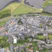
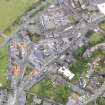
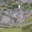
This site covers the Bo'ness Town Centre Area of Townscape Character which was defined as part of the Bo'ness Urban Survey Project 2013. The text below relates to the whole area.

Historical Development and Topography

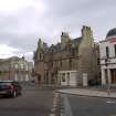
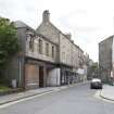
A relatively small area forms the historic core of the burgh focused on the triangle made by the L-plan North Street and South Street. This forms the basis of the boundary of the Bo’ness Town Centre Area of Townscape Character.

The town of Bo’ness, short for Borrowstounness, appears to come into existence in the early 17th century. The Hamiltons, also the Earls of Arran, were the principal local landowners with their estates centred on Kinneil House. They encouraged industrial development including coal mining and salt panning in the area, and were instrumental in the creation of the harbour and promoted trading links with the Baltic States and the Low Countries. The earliest part of the town developed on the shore around the harbour. In 1634 a new church was built in Bo’ness which was to replace the 12th century Kinneil Church as the parish church in 1669. This was also the year that Bo’ness became a Burgh of Regality. Dymock’s Buildings at 47–51 North Street is the only building to survive from this period, although the churchyard of the 1634 church also survives in Church Wynd. The new burgh flourished and became second only to Leith for the Baltic trade in the 18th century. Buildings such as the West Pier Tavern of 1711 and the Tobacco Warehouse of 1772, both in Scotland’s Close, reflect this prosperity. The core of the historic burgh was contained within the triangle formed by North and South Streets and Scotland’s Close and is still easily identifiable.

The fortunes of Bo’ness were dramatically altered in 1792 with the opening of the Forth and Clyde Canal. The canal entered the River Forth at nearby Grangemouth which then became the east coast port for Glasgow. Bo’ness continued to develop but at a slower pace. Industrial development took place to the east of the harbour along the foreshore linking the burgh to Grangepans and Bridgeness.

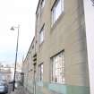
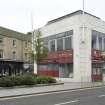
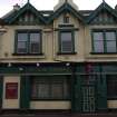
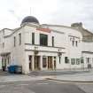
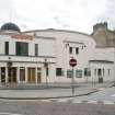
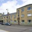
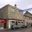
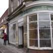
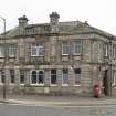
Much of the building stock of the town centre is 19th century with several important buildings by local architect Matthew Steele (1878-1937) including the shop on the ground floor at 11 South Street (1907), The Bo’ness Iron Company Offices at Dock Street/Union Street (1908), the circular Hippodrome Cinema (1911), the Art Deco cube of East and West Partings (now a shop) (1911), and the block of flats and shop at 1–11 Seaview Place (1936).

Late 19th/early 20th century public buildings like the Post Office (1911-12) and the Police Station (1891) were once on urban sites but are now on the edge of the town centre overlooking open space. The former industrial area to the east of the main town centre has been redeveloped with a large supermarket and car park which does not address any of the streets. The entrance to the store for pedestrians is within a long expanse of artificial stone walling, which probably represents the boundary wall of the former industrial premises which occupied the site.

Present Character

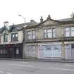
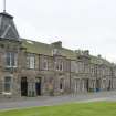
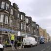
The Bo’ness Town Centre Area of Townscape Character has developed from the 17th century burgh street pattern with gap sites being turned into public open space and car parks. The town centre is now a predominantly 19th and early 20th century creation, with mostly three-storeyed, stone-built tenements with shops on the ground floor. Although the plots within the town centre are relatively small, the area has a fairly low density, given the scale of development within.

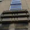
A few survivors from the early days of the burgh of Bo’ness can be found in this area, including Dymock’s Buildings on Scotland’s Close which dates from the 17th century with later additions and alterations. Restored in 2002-4 by The National Trust for Scotland, as part of its Little Houses Improvement Scheme, this displays many features which can be found across Scottish burghs –crowstepped gables, ochre-coloured lime harling and granite setts in the courtyard. Another early building in the town centre is at 13 South Street. Dating from 1750, this former tolbooth was heavily restored in 1981 but still retains many of its original features. Much of the town centre dates from the 19th century, when Bo’ness attracted many industries to set up along the shore to the east of the town centre. The development of the harbour and railway were key features in the establishment of the town as an industrial centre, as raw materials and the resulting products could be easily transported across Scotland and beyond. The original train station was located further west (where Seaview Place now is) from the current Bo’ness and Kinneil Station, which was created in the 1980s using buildings from stations across Scotland that were under threat of demolition. This includes a train shed (1842) from Haymarket in Edinburgh, a North British Railway station office (1887) from Wormit in Fife, and a footbridge (late 19th century) from Murthly in Perthshire.

Being the main shopping and commercial area of the town, most of the buildings have shops and offices at ground floor level, some retaining their original frontages, particularly from the Victorian era. The predominant building material in the town is sandstone, though some tenements have been harled or rendered, and several later buildings are built of brick.

The town centre also contains a large number of 20th century buildings, with several designed by local architect Matthew Steele.

Information from RCAHMS (LK), 12th August 2013

References

MyCanmore Image Contributions


Contribute an Image

MyCanmore Text Contributions