Accessibility

Font Size

100% 150% 200%

Background Colour

Default Contrast
Close Reset

Bo'ness, Drumpark Area Of Townscape Character

Town Quarter (Period Unassigned)

Site Name Bo'ness, Drumpark Area Of Townscape Character

Classification Town Quarter (Period Unassigned)

Canmore ID 312534

Site Number NT08SW 162

NGR NT 00880 80834

Datum OSGB36 - NGR

Permalink http://canmore.org.uk/site/312534

Ordnance Survey licence number AC0000807262. All rights reserved.
Canmore Disclaimer. © Bluesky International Limited 2025. Public Sector Viewing Terms

Toggle Aerial | View on large map

Digital Images

View of 1-15 Drumpark Avenue, Bo'ness, taken from the South-West. This photograph was taken as part of the Bo'ness Urban Survey to illustrate the character of the Drumpark Area of Townscape Character.
View of 1-15 Drumpark Avenue, Bo'ness, taken from the South-West. This photograph was taken as part of the Bo'ness Urban Survey to illustrate the character of the Drumpark Area of Townscape Character.View of 45-59 Drumpark Avenue, Bo'ness, taken from the North-East. The image shows deck accessed maisonette housing with shops below. This photograph was taken as part of the Bo'ness Urban Survey to illustrate the character of the Drumpark Area of Townscape Character.General street view showing 52-56 Drumacre Road, Bo'ness taken from the South-East. The building in the foreground is flatted accomodation, while two storey terraced housing can be seen in the background. This photograph was taken as part of the Bo'ness Urban Survey to illustrate the character of the Drumpark Area of Townscape Character.General street view taken from Drumacre Road, Bo'ness looking North. The image shows the rear of terraced housing at 16-26 and 28-40 Drumacre Road, including garden fencing and rear access lanes. The rear of maisonette housing at 45-59 Drumpark Avenue is also visible in the background. This photograph was taken as part of the Bo'ness Urban Survey to illustrate the character of the Drumpark Area of Townscape Character.General street view showing 1-19 Drumacre Road, Bo'ness, taken from the North-East. This photograph was taken as part of the Bo'ness Urban Survey to illustrate the character of the Drumpark Area of Townscape Character.View towards 44-52 Drumpark Avenue, Bo'ness, taken from the North-East across communal park land. This photograph was taken as part of the Bo'ness Urban Survey to illustrate the character of the Drumpark Area of Townscape Character.General oblique aerial view of Drumpark Area of Bo'ness, taken from SSE.View of rear of 80-90 Hadrian Way, Bo'ness. taken from South-East. The shared garage block and car parking can be seen in the foreground. This photograph was taken as part of the Bo'ness Urban Survey to illustrate the character of the Drumpark Area of Townscape Character.General oblique aerial view of Drumpark Area of Bo'ness, taken from SE.View of 18-30 Drum Road, Bo'ness, taken from the South-East. This image is of the front elevation of this terraced housing, showing front garden areas and access path. This photograph was taken as part of the Bo'ness Urban Survey to illustrate the character of the Drumpark Area of Townscape Character.General street view showing 18-30 Drum Road, Bo'ness, from the South-East. The image shows the terraced housing at right angles to the main access roads, with car parking to the left of the image and pedestrian access paths to the front of the housing. This photograph was taken as part of the Bo'ness Urban Survey to illustrate the character of the Drumpark Area of Townscape Character.View of 80-90 Hadrian Way, Bo'ness, taken from the East. This image shows the staggered entrances to the two storey terraced housing and pedestrian entrance paths. Garages and car parking are situated to the rear of the terrace. This photograph was taken as part of the Bo'ness Urban Survey to illustrate the character of the Drumpark Area of Townscape Character.General oblique aerial view of Drumpark Area of Bo'ness, taken from N.View towards terraced housing on Drumpark Avenue, Bo'ness, taken from the North-West across communal park land. This photograph was taken as part of the Bo'ness Urban Survey to illustrate the character of the Drumpark Area of Townscape Character.General oblique aerial view of Drumpark Area of Bo'ness, taken from E.General oblique aerial view of Forthview & Grahams Crescent, and Drumpark Areas of Townscape Character of Bo'ness, taken from NE.

Administrative Areas

  • Council Falkirk
  • Parish Bo'ness And Carriden
  • Former Region Central
  • Former District Falkirk
  • Former County West Lothian

Activities

Characterisation (25 November 2013)

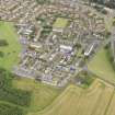
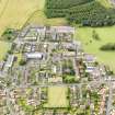
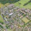
This site covers the Drumpark Area of Townscape Character which was defined as part of the Bo'ness Urban Survey Project 2013. The text below relates to the whole area.

Historical Development and Topography

The Drumpark Area of Townscape Character lies to the east of Bo’ness Academy’s playing fields at the end of Grahamsdyke Road, and adjacent to The Drum Area of Townscape Character.

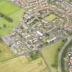
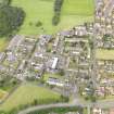
This area is a wholly mid- to late 20th century development, with a cluster of local authority built, two-storeyed, semi-detached housing in Hadrian Way and Drumpark Avenue, dating from the 1950s. These were subsequently surrounded by a large development of two- and three-storeyed, flat-roofed, terraced houses and flats, designed by Alison & Hutchison & Partners and built between 1964 and 1968. A total of 214 houses were built in this scheme at a total cost of £695,000. A large three-storeyed block of flats with neighbourhood shops on the ground floor is located in the centre of the scheme, and there are ranges of garages, or ‘lock-ups’, throughout the area.

There appears to have been some infilling with three-storeyed flatted blocks at 44–52 and 85–87 Drumpark Avenue, and 56–58 Hadrian Way. Each of these is partly cream-harled with a full-height projecting triangular small bay window within yellow brick.

Present Character

The Drumpark area still retains its 1960s street layout, and there have been few alterations to the buildings, barring general upgrading with double glazed windows or re-harling. The street pattern consists of terraced blocks of houses within straight cul-de-sacs with footpaths leading between the back gardens of the 1960s development. Plot sizes are small, making it densely packed, but its location on the southern edge of Bo’ness makes it feel fairly open.

The terraced houses have continuous glazing at first-floor level and full-height glazing to rooms at ground-floor level. Both the terraced houses and the flatted properties from the 1960s are flat-roofed, harled and have weatherboarding between the ground and first floors, mostly painted in varying shades of brown. Although the later blocks of flats have pitched roofs and yellow brick facings, they do fit in with the overall character of the area.

Information from RCAHMS (LK), 25th November 2013

References

MyCanmore Image Contributions


Contribute an Image

MyCanmore Text Contributions