
Bo'ness, The Drum Area Of Townscape Character


Town Quarter (Period Unassigned)
Site Name Bo'ness, The Drum Area Of Townscape Character
Classification Town Quarter (Period Unassigned)
Canmore ID 312533
Site Number NT08SW 161
NGR NT 01361 80832
Datum OSGB36 - NGR
Permalink http://canmore.org.uk/site/312533


- Council Falkirk
- Parish Bo'ness And Carriden
- Former Region Central
- Former District Falkirk
- Former County West Lothian
Characterisation (25 November 2013)
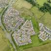
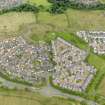
This site covers The Drum Area of Townscape Character which was defined as part of the Bo'ness Urban Survey Project 2013. The text below relates to the whole area.
Historical Development and Topography
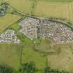
The Drum is a peripheral housing estate developed on a greenfield site radiating out from the site of Drum Farm on the outskirts of Bo’ness. The initial Masterplan for the area was developed by Alan Jeffrey with the landowner, Grange Estate, in 1999, identifying six phases of development to be carried out by different architects and builders.
Work began in 2001, and to date (2013) a variety of houses have been designed and built by three pairings of house builders and architects: Mactaggart & Mickel with Austin-Smith:Lord (Phase One); Ogilvie Homes with Vernon Monaghan Architect (Phase Two); and Stewart Milne with Malcolm Fraser Architects (Phase Three).
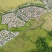
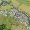
The development is accessed via a roundabout just off Grahamsdyke Road, and comprises a series of crescents, cul-de-sacs, courtyards and terraces. The street pattern gives the area a rural, village feel, with shared green spaces throughout. Further development is expected to take place, including a proposed business park to the south and south-east of the current area.
Present Character
Although a 21st century creation, The Drum incorporates several traditional architectural and urban design features. The layout comes from the curving Hillside Drive/Muirhouses Avenue in the south of the area, with roads radiating inwards to the north. The Stewart Milne/Malcolm Fraser phase in the north-eastern corner (Maryfield Drive and Muirhouses Square) has been developed with an open communal square and no through routes, while the earlier phase around Muirhouses Crescent/Avenue and Carriden Place/View consists of two circuits. The phase in the west has a series of three streets connecting the two crescents of Hillside Drive and Acre View.
There are a variety of plot sizes, the largest being in the north-eastern corner with its two-storeyed detached houses set in line around the cul-de-sacs. Medium-sized plots make up the central area, with uniform lines of two-storeyed detached houses in the south, and more randomly placed two-storeyed detached houses on either side of Muirhouses Avenue. The streetline of the flatted and terraced single-, two- and three-storeyed housing in the western section has been varied to break up the streetscape, and give an impression of more phased development, rather than a uniform line of building. This area has the smallest plot sizes but also has the most shared open space.
The majority of the housing in the area has been rendered and whitewashed. Some traditional features have been incorporated across the development, with gabled frontages, a mixture of tiled and pantiled roofs and pend accesses to rear courtyards throughout the western section. Charles Rennie Mackintosh-inspired detailing has been used in the central section, including the stunted broad chimney stacks breaking up the gables on side elevations.
Information from RCAHMS (LK), 25th November 2013

