
Bo'ness, Muirhouses Area Of Townscape Character


Town Quarter (Period Unassigned)
Site Name Bo'ness, Muirhouses Area Of Townscape Character
Classification Town Quarter (Period Unassigned)
Canmore ID 312532
Site Number NT08SW 160
NGR NT 01890 80531
Datum OSGB36 - NGR
Permalink http://canmore.org.uk/site/312532


- Council Falkirk
- Parish Bo'ness And Carriden
- Former Region Central
- Former District Falkirk
- Former County West Lothian
Characterisation (20 November 2013)
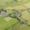
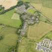
This site covers the Muirhouses Area of Townscape Character which was defined as part of the Bo'ness Urban Survey Project 2013. The text below relates to the whole area.
Historical Development and Topography
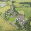
Muirhouses is a separate hamlet to the south-east of Bo’ness, which is purely a 19th century creation. Developed as a model estate village by Admiral Sir James Hope (1808-81) of the Carriden Estate to house his estate workers, it remains separated from the main urban area of Bo’ness.
The West Lodge to Carriden House is the earliest building in the area and is to the north of the main centre of Muirhouses, on the road leading north towards Carriden and then to Bo’ness. Built in 1844, this single- and two-storeyed lodge was originally a school for girls (as shown on the OS 1st Edition 1854), but was probably converted to the West Lodge when the new school and schoolhouse was built to the south in 1866.
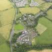
During the period 1864 to 1874, a series of semi-detached cottages were built at Muirhouses at the junction between Carriden Brae and Acre Road. In addition, the new school had an adjoining schoolhouse and a library (c.1870).
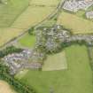
The area remained relatively unchanged until Grangewells on Acre Road was built in 1911, designed by local architect Matthew Steele (1878-1937). During the immediate post-WWII period, some ribbon development took place along Carriden Brae to the north of Acre Road (late 1940s), as well as two phases of social housing being built in the south-east corner of the area around Gledhill Avenue (late 1940s) and Miller Crescent (early 1950s). Subsequent development in the area has been piecemeal infilling of plots.
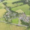
Present Character
The area of Muirhouses is mostly linear along Carriden Brae and Acre Road. The majority of the area’s character is rustic rural with the model village development by Admiral Sir James Hope from 1864 to 1874. This development was built in a similar single- and two-storeyed ‘Cottage Ornée’ style, with small latticed windows and hipped roofs, all set within large garden plots bounded by low stone boundary walls and hedges adding to the country feel of the area. The core of the ‘village’ is stone-built with slate roofs and ornate carved stonework such as corbelled gable to the former school.
The later 20th century development retains this character, with two-storeyed terraced houses being set out around a crescent and semi-detached single-storeyed cottages set out in a neat H-plan. These are all typical examples of the period, being brick-built and rendered and set within reasonably large plots in keeping with the earlier development.
Information from RCAHMS (LK), 20th November 2013

