
Peanmeanach


Bothy (20th Century) (1975), Township (Post Medieval)
Site Name Peanmeanach
Classification Bothy (20th Century) (1975), Township (Post Medieval)
Canmore ID 312007
Site Number NM78SW 25
NGR NM 7123 8049
Datum OSGB36 - NGR
Permalink http://canmore.org.uk/site/312007


- Council Highland
- Parish Arisaig And Moidart
- Former Region Highland
- Former District Lochaber
- Former County Inverness-shire
Note (4 July 2022)
NM78SW 25 NM 71215 80514
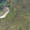
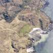
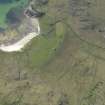
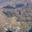
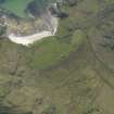
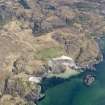
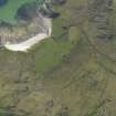
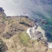
This bothy occupies a cottage within the former crofting township of Peanmeanach, one of series of five abandoned settlements along the SW coast of the Ardnish peninsula (the others being Sloch, Glasnacardoch, Feorlindhu and Laggan). The single storey 3-bay cottage is one of a group of buildings set in a shallow arc some 130m back from the shore and, with two other cottages nearby, is one of the more recent buildings in the group. The extensive remains of cultivation extend to the N and S of the building, while peat cuttings are visible in the higher ground 160m to the N.
Peanmeanach was depicted as a group of 16 roofed buildings on the 1st edition of the OS 6-inch map (Inverness-shire, sheet cxxxv, 1876) and it was described at the time as ‘a cluster of houses…they are thatched and in middling repair, the property of the Trustees of the late F D P Astley Esqr [1825-1868]’ (OS Name Book, Inverness-shire No. 9, p. 26). The Valuation Roll for Ardnamurchan in 1885-6 listed the tenants at Peanmeanach as Ronald Maceachan, Donald Macdonald, Ewen Macdonald, Isabella Macdonald, Simon Macdonald and Roderick Macdonald. The building now used as the bothy does not appear to be depicted on the 1st edition map, but is shown on the 2nd edition map (Inverness-shire, sheet cxxxv, 1900).
Information from HES Archaeological Survey (D M Bratt and G F Geddes) 4 July 2022
(Allan 2017, 132-3)

