
Pricing Change
New pricing for orders of material from this site will come into place shortly. Charges for supply of digital images, digitisation on demand, prints and licensing will be altered.
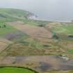
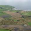
West Myroch


Field Boundary(S) (Period Unassigned), Pit(S) (Period Unassigned), Rig And Furrow (Medieval) - (Post Medieval)
Site Name West Myroch
Classification Field Boundary(S) (Period Unassigned), Pit(S) (Period Unassigned), Rig And Furrow (Medieval) - (Post Medieval)
Canmore ID 311684
Site Number NX14SW 47
NGR NX 10756 41337
Datum OSGB36 - NGR
Permalink http://canmore.org.uk/site/311684


- Council Dumfries And Galloway
- Parish Kirkmaiden
- Former Region Dumfries And Galloway
- Former District Wigtown
- Former County Wigtownshire
NX14SW 47 10756 41337
These pits have been recorded as cropmarks on oblique aerial photographs (RCAHMSAP 2008).
There are also a few rigs orientated N-S,a nd some lengths of ploughed out field boundaries.
Information from RCAHMS (KHJM) 10 Nov 2011
Aerial Photography (8 August 2008)
Aerial Photographic Transcription (10 November 2011)

