
Following the launch of trove.scot in February 2025 we are now planning the retiral of some of our webservices. Canmore will be switched off on 24th June 2025. Information about the closure can be found on the HES website: Retiral of HES web services | Historic Environment Scotland
Inverewe


Fish Trap (Period Unassigned)
Site Name Inverewe
Classification Fish Trap (Period Unassigned)
Canmore ID 311163
Site Number NG88SE 58
NGR NG 8604 8181
Datum OSGB36 - NGR
Permalink http://canmore.org.uk/site/311163


- Council Highland
- Parish Gairloch
- Former Region Highland
- Former District Ross And Cromarty
- Former County Ross And Cromarty
NG88SE 58 8604 8181
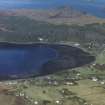
This fish trap comprises a band of rubble extending out into the bay from the shore at Inverewe. It measures some 70m into the bay by at least 135m. The SE side is very straight by comparison with the broader and less regular line of the rest of the rubble band.
Information from RCAHMS (DCC) 6 June 2011

