
Myretoun


Barn (Post Medieval)
Site Name Myretoun
Classification Barn (Post Medieval)
Canmore ID 311014
Site Number NS89NE 156
NGR NS 8572 9718
Datum OSGB36 - NGR
Permalink http://canmore.org.uk/site/311014
Ordnance Survey licence number AC0000807262. All rights reserved.
Canmore Disclaimer.
© Bluesky International Limited 2025. Public Sector Viewing Terms
- Correction
- Favourite

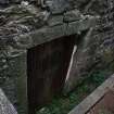
DP 183010
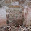
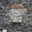
External view of blocked door F03
Records from Headland Archaeology Ltd, archaeologists, Edinburgh, Scotland
10/2010
© Copyright: Headland Archaeology Ltd.. Courtesy of HES.

DP 183021
External view of south half of east wall from the E
Records from Headland Archaeology Ltd, archaeologists, Edinburgh, Scotland
10/2010
© Copyright: Headland Archaeology Ltd.. Courtesy of HES.

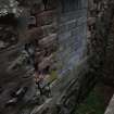
DP 183032
General view of the west wall from the SW
Records from Headland Archaeology Ltd, archaeologists, Edinburgh, Scotland
10/2010
© Copyright: Headland Archaeology Ltd.. Courtesy of HES.

DP 183048
South internal wall of Room C including door F29
Records from Headland Archaeology Ltd, archaeologists, Edinburgh, Scotland
10/2010
© Copyright: Headland Archaeology Ltd.. Courtesy of HES.

DP 183049
Internal view of SW corner of Room C
Records from Headland Archaeology Ltd, archaeologists, Edinburgh, Scotland
10/2010
© Copyright: Headland Archaeology Ltd.. Courtesy of HES.

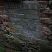
DP 183056
General external view of south wall
Records from Headland Archaeology Ltd, archaeologists, Edinburgh, Scotland
10/2010
© Copyright: Headland Archaeology Ltd.. Courtesy of HES.

DP 183067
View of next door cottage
Records from Headland Archaeology Ltd, archaeologists, Edinburgh, Scotland
10/2010
© Copyright: Headland Archaeology Ltd.. Courtesy of HES.

DP 183074
General view of building from the NW
Records from Headland Archaeology Ltd, archaeologists, Edinburgh, Scotland
10/2010
© Copyright: Headland Archaeology Ltd.. Courtesy of HES.

DP 182985
Internal shot of the roof timbers above Room A
Records from Headland Archaeology Ltd, archaeologists, Edinburgh, Scotland
10/2010
© Copyright: Headland Archaeology Ltd.. Courtesy of HES.

DP 182989
Internal detail of blocked door on west wall of Room A, F28
Records from Headland Archaeology Ltd, archaeologists, Edinburgh, Scotland
10/2010
© Copyright: Headland Archaeology Ltd.. Courtesy of HES.

DP 182993
Internal view of upper fl oor door on west wall of Room C, F05
Records from Headland Archaeology Ltd, archaeologists, Edinburgh, Scotland
10/2010
© Copyright: Headland Archaeology Ltd.. Courtesy of HES.

DP 182994
Internal view of blocked ground fl oor window on west wall of Room C, F06
Records from Headland Archaeology Ltd, archaeologists, Edinburgh, Scotland
10/2010
© Copyright: Headland Archaeology Ltd.. Courtesy of HES.

DP 182995
Internal detail of upper window on west wall of Room C, F07
Records from Headland Archaeology Ltd, archaeologists, Edinburgh, Scotland
10/2010
© Copyright: Headland Archaeology Ltd.. Courtesy of HES.

DP 182999
Corbel on internal east wall of Room B, F30
Records from Headland Archaeology Ltd, archaeologists, Edinburgh, Scotland
10/2010
© Copyright: Headland Archaeology Ltd.. Courtesy of HES.

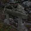
DP 183009
Detail of the south side of the steps F04
Records from Headland Archaeology Ltd, archaeologists, Edinburgh, Scotland
10/2010
© Copyright: Headland Archaeology Ltd.. Courtesy of HES.

DP 183011
Detail of north side of steps F04
Records from Headland Archaeology Ltd, archaeologists, Edinburgh, Scotland
10/2010
© Copyright: Headland Archaeology Ltd.. Courtesy of HES.

DP 183012
External view of upper fl oor window F07
Records from Headland Archaeology Ltd, archaeologists, Edinburgh, Scotland
10/2010
© Copyright: Headland Archaeology Ltd.. Courtesy of HES.

DP 183036
General internal view of Room A showing the west wall
Records from Headland Archaeology Ltd, archaeologists, Edinburgh, Scotland
10/2010
© Copyright: Headland Archaeology Ltd.. Courtesy of HES.

DP 183044
Internal detail of window F07 & door F06
Records from Headland Archaeology Ltd, archaeologists, Edinburgh, Scotland
10/2010
© Copyright: Headland Archaeology Ltd.. Courtesy of HES.

DP 183052
Internal detail of window F10
Records from Headland Archaeology Ltd, archaeologists, Edinburgh, Scotland
10/2010
© Copyright: Headland Archaeology Ltd.. Courtesy of HES.

DP 183057
General external view of west half of the south wall
Records from Headland Archaeology Ltd, archaeologists, Edinburgh, Scotland
10/2010
© Copyright: Headland Archaeology Ltd.. Courtesy of HES.

DP 183061
External detail of door F12 & window F13
Records from Headland Archaeology Ltd, archaeologists, Edinburgh, Scotland
10/2010
© Copyright: Headland Archaeology Ltd.. Courtesy of HES.

DP 183066
External view of the roof gables
Records from Headland Archaeology Ltd, archaeologists, Edinburgh, Scotland
10/2010
© Copyright: Headland Archaeology Ltd.. Courtesy of HES.

DP 183069
External detail of north side of steps F04
Records from Headland Archaeology Ltd, archaeologists, Edinburgh, Scotland
10/2010
© Copyright: Headland Archaeology Ltd.. Courtesy of HES.

DP 183078
External detail of the repair to the south wall
Records from Headland Archaeology Ltd, archaeologists, Edinburgh, Scotland
10/2010
© Copyright: Headland Archaeology Ltd.. Courtesy of HES.

DP 183122
Illustrations from a historic building survey of Myretoun Barn, Menstrie, Stirling.
Records from Headland Archaeology Ltd, archaeologists, Edinburgh, Scotland
10/2010
© Copyright: Headland Archaeology Ltd.. Courtesy of HES.

DP 183125
Illustrations from a historic building survey of Myretoun Barn, Menstrie, Stirling.
Records from Headland Archaeology Ltd, archaeologists, Edinburgh, Scotland
10/2010
© Copyright: Headland Archaeology Ltd.. Courtesy of HES.

DP 182987
Detail of original beams in Room A
Records from Headland Archaeology Ltd, archaeologists, Edinburgh, Scotland
10/2010
© Copyright: Headland Archaeology Ltd.. Courtesy of HES.

DP 182990
General shot of roof of Room A
Records from Headland Archaeology Ltd, archaeologists, Edinburgh, Scotland
10/2010
© Copyright: Headland Archaeology Ltd.. Courtesy of HES.

DP 182997
General view of internal elevation of north wall
Records from Headland Archaeology Ltd, archaeologists, Edinburgh, Scotland
10/2010
© Copyright: Headland Archaeology Ltd.. Courtesy of HES.

DP 183007
General external view of gable ends on north wall
Records from Headland Archaeology Ltd, archaeologists, Edinburgh, Scotland
10/2010
© Copyright: Headland Archaeology Ltd.. Courtesy of HES.

DP 183008
General external view of gable ends on north wall
Records from Headland Archaeology Ltd, archaeologists, Edinburgh, Scotland
10/2010
© Copyright: Headland Archaeology Ltd.. Courtesy of HES.

DP 183031
West side of the south wall from the SW
Records from Headland Archaeology Ltd, archaeologists, Edinburgh, Scotland
10/2010
© Copyright: Headland Archaeology Ltd.. Courtesy of HES.

DP 183038
Internal detail of door F28
Records from Headland Archaeology Ltd, archaeologists, Edinburgh, Scotland
10/2010
© Copyright: Headland Archaeology Ltd.. Courtesy of HES.

DP 183053
Detail of door F28 on east wall of Room B
Records from Headland Archaeology Ltd, archaeologists, Edinburgh, Scotland
10/2010
© Copyright: Headland Archaeology Ltd.. Courtesy of HES.

DP 183063
General external view of the NE corner of the building
Records from Headland Archaeology Ltd, archaeologists, Edinburgh, Scotland
10/2010
© Copyright: Headland Archaeology Ltd.. Courtesy of HES.

DP 183064
External detail of window F09
Records from Headland Archaeology Ltd, archaeologists, Edinburgh, Scotland
10/2010
© Copyright: Headland Archaeology Ltd.. Courtesy of HES.

DP 182988
Internal detail of window F19 on north wall in Room A
Records from Headland Archaeology Ltd, archaeologists, Edinburgh, Scotland
10/2010
© Copyright: Headland Archaeology Ltd.. Courtesy of HES.

DP 183003
Internal detail of wall junction NE corner of Room B
Records from Headland Archaeology Ltd, archaeologists, Edinburgh, Scotland
10/2010
© Copyright: Headland Archaeology Ltd.. Courtesy of HES.

DP 183004
Internal view of blocked door on east wall of Room B, F28
Records from Headland Archaeology Ltd, archaeologists, Edinburgh, Scotland
10/2010
© Copyright: Headland Archaeology Ltd.. Courtesy of HES.

DP 183023
External view of north half of east wall from the E
Records from Headland Archaeology Ltd, archaeologists, Edinburgh, Scotland
10/2010
© Copyright: Headland Archaeology Ltd.. Courtesy of HES.

DP 183025
External view of the east half of the north wall from the N
Records from Headland Archaeology Ltd, archaeologists, Edinburgh, Scotland
10/2010
© Copyright: Headland Archaeology Ltd.. Courtesy of HES.

DP 183028
View of the roof over Room A
Records from Headland Archaeology Ltd, archaeologists, Edinburgh, Scotland
10/2010
© Copyright: Headland Archaeology Ltd.. Courtesy of HES.

DP 183045
North end of interior west wall of Room C
Records from Headland Archaeology Ltd, archaeologists, Edinburgh, Scotland
10/2010
© Copyright: Headland Archaeology Ltd.. Courtesy of HES.

DP 182996
General internal view of north gable of Room C
Records from Headland Archaeology Ltd, archaeologists, Edinburgh, Scotland
10/2010
© Copyright: Headland Archaeology Ltd.. Courtesy of HES.

DP 182998
Internal view of the north gable in Room B
Records from Headland Archaeology Ltd, archaeologists, Edinburgh, Scotland
10/2010
© Copyright: Headland Archaeology Ltd.. Courtesy of HES.

DP 183006
General shot of roof line from the NW
Records from Headland Archaeology Ltd, archaeologists, Edinburgh, Scotland
10/2010
© Copyright: Headland Archaeology Ltd.. Courtesy of HES.

DP 183014
External view of beam slots F22 on west elevation
Records from Headland Archaeology Ltd, archaeologists, Edinburgh, Scotland
10/2010
© Copyright: Headland Archaeology Ltd.. Courtesy of HES.

DP 183017
External view of windows F16 & F17 on east wall
Records from Headland Archaeology Ltd, archaeologists, Edinburgh, Scotland
10/2010
© Copyright: Headland Archaeology Ltd.. Courtesy of HES.

DP 183019
External view of brick blocked window F10
Records from Headland Archaeology Ltd, archaeologists, Edinburgh, Scotland
10/2010
© Copyright: Headland Archaeology Ltd.. Courtesy of HES.

DP 183024
External view of the east half of the north wall from the N
Records from Headland Archaeology Ltd, archaeologists, Edinburgh, Scotland
10/2010
© Copyright: Headland Archaeology Ltd.. Courtesy of HES.

DP 183043
Internal detail of windows F10 & F11
Records from Headland Archaeology Ltd, archaeologists, Edinburgh, Scotland
10/2010
© Copyright: Headland Archaeology Ltd.. Courtesy of HES.

DP 183054
External view of window F23
Records from Headland Archaeology Ltd, archaeologists, Edinburgh, Scotland
10/2010
© Copyright: Headland Archaeology Ltd.. Courtesy of HES.

DP 183055
External view of door F24 on west wall
Records from Headland Archaeology Ltd, archaeologists, Edinburgh, Scotland
10/2010
© Copyright: Headland Archaeology Ltd.. Courtesy of HES.

DP 183059
External view of the south and east walls
Records from Headland Archaeology Ltd, archaeologists, Edinburgh, Scotland
10/2010
© Copyright: Headland Archaeology Ltd.. Courtesy of HES.

DP 183060
External detail of window F15
Records from Headland Archaeology Ltd, archaeologists, Edinburgh, Scotland
10/2010
© Copyright: Headland Archaeology Ltd.. Courtesy of HES.

DP 183068
External detail of window F06
Records from Headland Archaeology Ltd, archaeologists, Edinburgh, Scotland
10/2010
© Copyright: Headland Archaeology Ltd.. Courtesy of HES.

DP 183070
External detail of door F03
Records from Headland Archaeology Ltd, archaeologists, Edinburgh, Scotland
10/2010
© Copyright: Headland Archaeology Ltd.. Courtesy of HES.

DP 183071
External detail of door F01
Records from Headland Archaeology Ltd, archaeologists, Edinburgh, Scotland
10/2010
© Copyright: Headland Archaeology Ltd.. Courtesy of HES.

DP 183072
External detail of door F01
Records from Headland Archaeology Ltd, archaeologists, Edinburgh, Scotland
10/2010
© Copyright: Headland Archaeology Ltd.. Courtesy of HES.

DP 183121
Illustrations from a historic building survey of Myretoun Barn, Menstrie, Stirling.
Records from Headland Archaeology Ltd, archaeologists, Edinburgh, Scotland
10/2010
© Copyright: Headland Archaeology Ltd.. Courtesy of HES.

DP 183123
Illustrations from a historic building survey of Myretoun Barn, Menstrie, Stirling.
Records from Headland Archaeology Ltd, archaeologists, Edinburgh, Scotland
10/2010
© Copyright: Headland Archaeology Ltd.. Courtesy of HES.

DP 183000
Corbel on internal west wall of Room B, F30
Records from Headland Archaeology Ltd, archaeologists, Edinburgh, Scotland
10/2010
© Copyright: Headland Archaeology Ltd.. Courtesy of HES.

DP 183001
Roof beam on internal north wall of Room B
Records from Headland Archaeology Ltd, archaeologists, Edinburgh, Scotland
10/2010
© Copyright: Headland Archaeology Ltd.. Courtesy of HES.

DP 183005
External detail of window F23
Records from Headland Archaeology Ltd, archaeologists, Edinburgh, Scotland
10/2010
© Copyright: Headland Archaeology Ltd.. Courtesy of HES.

DP 183018
External view of gable end on the NE corner
Records from Headland Archaeology Ltd, archaeologists, Edinburgh, Scotland
10/2010
© Copyright: Headland Archaeology Ltd.. Courtesy of HES.

DP 183020
General view of south wall from the SE
Records from Headland Archaeology Ltd, archaeologists, Edinburgh, Scotland
10/2010
© Copyright: Headland Archaeology Ltd.. Courtesy of HES.

DP 183026
General shot of the barn from the NE
Records from Headland Archaeology Ltd, archaeologists, Edinburgh, Scotland
10/2010
© Copyright: Headland Archaeology Ltd.. Courtesy of HES.

DP 183034
General internal view of Room A
Records from Headland Archaeology Ltd, archaeologists, Edinburgh, Scotland
10/2010
© Copyright: Headland Archaeology Ltd.. Courtesy of HES.

DP 183047
General interior view of Room C
Records from Headland Archaeology Ltd, archaeologists, Edinburgh, Scotland
10/2010
© Copyright: Headland Archaeology Ltd.. Courtesy of HES.

DP 183062
Detail of quoins on the NE corner of the barn
Records from Headland Archaeology Ltd, archaeologists, Edinburgh, Scotland
10/2010
© Copyright: Headland Archaeology Ltd.. Courtesy of HES.

DP 183073
Detail of south side of steps F04
Records from Headland Archaeology Ltd, archaeologists, Edinburgh, Scotland
10/2010
© Copyright: Headland Archaeology Ltd.. Courtesy of HES.

DP 183118
Illustrations from a historic building survey of Myretoun Barn, Menstrie, Stirling.
Records from Headland Archaeology Ltd, archaeologists, Edinburgh, Scotland
10/2010
© Copyright: Headland Archaeology Ltd.. Courtesy of HES.

DP 183120
Illustrations from a historic building survey of Myretoun Barn, Menstrie, Stirling.
Records from Headland Archaeology Ltd, archaeologists, Edinburgh, Scotland
10/2010
© Copyright: Headland Archaeology Ltd.. Courtesy of HES.

DP 183126
Illustrations from a historic building survey of Myretoun Barn, Menstrie, Stirling.
Records from Headland Archaeology Ltd, archaeologists, Edinburgh, Scotland
10/2010
© Copyright: Headland Archaeology Ltd.. Courtesy of HES.

DP 182986
Internal shot of the roof timbers above Room A
Records from Headland Archaeology Ltd, archaeologists, Edinburgh, Scotland
10/2010
© Copyright: Headland Archaeology Ltd.. Courtesy of HES.

DP 183002
Internal view of the north gable wall in Room B
Records from Headland Archaeology Ltd, archaeologists, Edinburgh, Scotland
10/2010
© Copyright: Headland Archaeology Ltd.. Courtesy of HES.

DP 183022
External view of middle section of east wall from the E
Records from Headland Archaeology Ltd, archaeologists, Edinburgh, Scotland
10/2010
© Copyright: Headland Archaeology Ltd.. Courtesy of HES.

DP 183035
General internal view of Room A showing the east wall
Records from Headland Archaeology Ltd, archaeologists, Edinburgh, Scotland
10/2010
© Copyright: Headland Archaeology Ltd.. Courtesy of HES.

DP 183040
General internal view of Room D
Records from Headland Archaeology Ltd, archaeologists, Edinburgh, Scotland
10/2010
© Copyright: Headland Archaeology Ltd.. Courtesy of HES.

DP 183050
NW corner of Room B showing the foundation stones
Records from Headland Archaeology Ltd, archaeologists, Edinburgh, Scotland
10/2010
© Copyright: Headland Archaeology Ltd.. Courtesy of HES.

DP 183051
Internal detail of window F31
Records from Headland Archaeology Ltd, archaeologists, Edinburgh, Scotland
10/2010
© Copyright: Headland Archaeology Ltd.. Courtesy of HES.

DP 183065
External view of the roof gables
Records from Headland Archaeology Ltd, archaeologists, Edinburgh, Scotland
10/2010
© Copyright: Headland Archaeology Ltd.. Courtesy of HES.

DP 183075
Detail of NW corner of the building
Records from Headland Archaeology Ltd, archaeologists, Edinburgh, Scotland
10/2010
© Copyright: Headland Archaeology Ltd.. Courtesy of HES.

DP 183079
View of building from the road to the south
Records from Headland Archaeology Ltd, archaeologists, Edinburgh, Scotland
10/2010
© Copyright: Headland Archaeology Ltd.. Courtesy of HES.

DP 183119
Illustrations from a historic building survey of Myretoun Barn, Menstrie, Stirling.
Records from Headland Archaeology Ltd, archaeologists, Edinburgh, Scotland
10/2010
© Copyright: Headland Archaeology Ltd.. Courtesy of HES.

DP 183124
Illustrations from a historic building survey of Myretoun Barn, Menstrie, Stirling.
Records from Headland Archaeology Ltd, archaeologists, Edinburgh, Scotland
10/2010
© Copyright: Headland Archaeology Ltd.. Courtesy of HES.

DP 182991
Door F29 on upper fl oor of south wall of Room C
Records from Headland Archaeology Ltd, archaeologists, Edinburgh, Scotland
10/2010
© Copyright: Headland Archaeology Ltd.. Courtesy of HES.

DP 183013
External view of blocked window F06
Records from Headland Archaeology Ltd, archaeologists, Edinburgh, Scotland
10/2010
© Copyright: Headland Archaeology Ltd.. Courtesy of HES.

DP 183015
External view of blocked and truncated window F08
Records from Headland Archaeology Ltd, archaeologists, Edinburgh, Scotland
10/2010
© Copyright: Headland Archaeology Ltd.. Courtesy of HES.

DP 183029
External view of detail of door F21 on the south wall
Records from Headland Archaeology Ltd, archaeologists, Edinburgh, Scotland
10/2010
© Copyright: Headland Archaeology Ltd.. Courtesy of HES.

DP 183030
East side of the south elevation from the S
Records from Headland Archaeology Ltd, archaeologists, Edinburgh, Scotland
10/2010
© Copyright: Headland Archaeology Ltd.. Courtesy of HES.

DP 183033
External detail of the south half of the west wall
Records from Headland Archaeology Ltd, archaeologists, Edinburgh, Scotland
10/2010
© Copyright: Headland Archaeology Ltd.. Courtesy of HES.

DP 183037
Internal detail of window F19
Records from Headland Archaeology Ltd, archaeologists, Edinburgh, Scotland
10/2010
© Copyright: Headland Archaeology Ltd.. Courtesy of HES.

DP 183039
Internal view of Room A and opening F27
Records from Headland Archaeology Ltd, archaeologists, Edinburgh, Scotland
10/2010
© Copyright: Headland Archaeology Ltd.. Courtesy of HES.

DP 183076
General view of the building from the NE
Records from Headland Archaeology Ltd, archaeologists, Edinburgh, Scotland
10/2010
© Copyright: Headland Archaeology Ltd.. Courtesy of HES.

DP 183117
Illustrations from a historic building survey of Myretoun Barn, Menstrie, Stirling.
Records from Headland Archaeology Ltd, archaeologists, Edinburgh, Scotland
10/2010
© Copyright: Headland Archaeology Ltd.. Courtesy of HES.


- Council Clackmannan
- Parish Alva
- Former Region Central
- Former District Clackmannan
- Former County Clackmannanshire
Standing Building Recording (27 September 2010 - 28 September 2010)
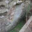
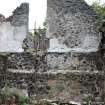
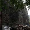
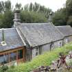
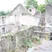
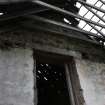
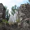
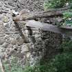
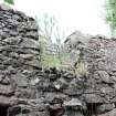
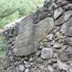
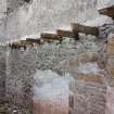
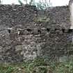
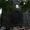
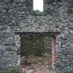
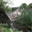
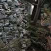
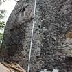
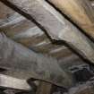
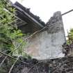
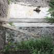
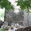
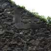
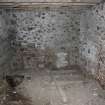
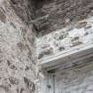
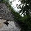
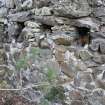
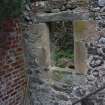
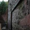
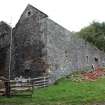
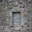
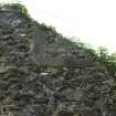
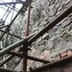
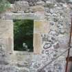
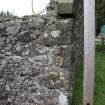
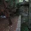
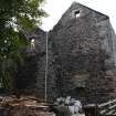
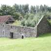
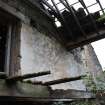
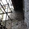
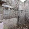
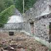
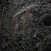
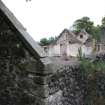
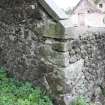
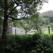
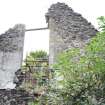
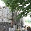
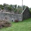
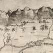
NS 8572 9718 A desk-based assessment and programme of building recording were undertaken 27–28 September 2010. The building, which is thought to date to the late 18th century, consisted of a two-storey barn constructed of rubble stone along a steep south-facing slope. It was in a poor state of repair with only a small section of the roof surviving and many of the walls showed signs of collapse. Several phases of alterations were recorded, including the insertion and blocking of windows and doors as well as a significant change in the roof design, from a wide single pitch to a double pitch with double gables at each end. The form and location of the building suggest that it was probably used as livestock shelter with a large upper wool storage area.
Archive: RCAHMS
Funder: OMI Architects
Donald Wilson – Headland Archaeology Ltd

