
Following the launch of trove.scot in February 2025 we are now planning the retiral of some of our webservices. Canmore will be switched off on 24th June 2025. Information about the closure can be found on the HES website: Retiral of HES web services | Historic Environment Scotland
Fisherfield


Building (Period Unassigned), Enclosure (Period Unassigned), Farmstead (Period Unassigned)(Possible), Sheepfold (Period Unassigned)
Site Name Fisherfield
Classification Building (Period Unassigned), Enclosure (Period Unassigned), Farmstead (Period Unassigned)(Possible), Sheepfold (Period Unassigned)
Canmore ID 310948
Site Number NG99SE 27
NGR NG 9554 9089
Datum OSGB36 - NGR
Permalink http://canmore.org.uk/site/310948


- Council Highland
- Parish Lochbroom
- Former Region Highland
- Former District Ross And Cromarty
- Former County Ross And Cromarty
NG99SE 27 9554 9089
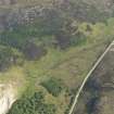
Oblique aerial photography (RCAHMSAP 2009) has recorded what are probably the remains of a farmstead 560m WSW of the current settlement at Fisherfield. The ‘sheepfold’ was depicted on the 1st edition of the OS 6-inch map (Ross-shire and Cromartyshire 1881, Sheet XX), when it comprised four enclosures, a roofed building, and what is probably an unroofed building.
Information from RCAHMS (GFG) 9 May 2011.

