
Pricing Change
New pricing for orders of material from this site will come into place shortly. Charges for supply of digital images, digitisation on demand, prints and licensing will be altered.
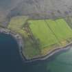
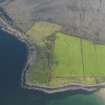
Rubha Na Moine


Lazy Beds (Post Medieval)
Site Name Rubha Na Moine
Classification Lazy Beds (Post Medieval)
Alternative Name(s) Mungasdale
Canmore ID 310945
Site Number NG99SE 24
NGR NG 9631 9369
Datum OSGB36 - NGR
Permalink http://canmore.org.uk/site/310945


- Council Highland
- Parish Lochbroom
- Former Region Highland
- Former District Ross And Cromarty
- Former County Ross And Cromarty
NG99SE 24 9631 9369
Oblique aerial photography (RCAHMSAP 2009) has recorded the remains of cultivation to the NE and SE of Rubha na Moine point, on the N side of Mungasdale Bay. Linear features that are visible further to the NE, centred NG 964 940, are probably natural.
Information from RCAHMS (GFG) 9 May 2011.
Note (9 May 2011)
Oblique aerial photography (RCAHMSAP 2009) has recorded the remains of cultivation to the NE and SE of Rubha na Moine point, on the N side of Mungasdale Bay. Linear features that are visible further to the NE, centred NG 964 940, are probably natural.
Information from RCAHMS (GFG) 9 May 2011.

