
Glenarigolach


Field System (Period Unassigned)
Site Name Glenarigolach
Classification Field System (Period Unassigned)
Canmore ID 310942
Site Number NG98NE 12
NGR NG 987 892
Datum OSGB36 - NGR
Permalink http://canmore.org.uk/site/310942

- Council Highland
- Parish Lochbroom
- Former Region Highland
- Former District Ross And Cromarty
- Former County Ross And Cromarty
NG98NE 12 987 892
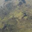
A group of at least four fields is visible on oblique aerial photographs (RCAHMSAP 2009) on the N side of an unnamed tributary of the Allt a’Ghlinne. The fields, depicted on the 1st edition of the OS 6-inch map (Ross-shire and Cromartshire 1881, Sheet XX), and current OS raster mapping, may have been related to the township of Glenarigolach (NG98NE 2).
Information from RCAHMS (GFG) 9 May 2011.
Note (9 May 2011)
A group of at least four fields is visible on oblique aerial photographs (RCAHMSAP 2009) on the N side of an unnamed tributary of the Allt a’Ghlinne. The fields, depicted on the 1st edition of the OS 6-inch map (Ross-shire and Cromartshire 1881, Sheet XX), and current OS raster mapping, may have been related to the township of Glenarigolach (NG98NE 2).
Information from RCAHMS (GFG) 9 May 2011.

