
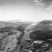
Caledonian Canal, North Laggan, Canal Embankment


Canal (Period Unassigned)
Site Name Caledonian Canal, North Laggan, Canal Embankment
Classification Canal (Period Unassigned)
Canmore ID 310357
Site Number NN39NE 5
NGR NN 30063 98358
Datum OSGB36 - NGR
Permalink http://canmore.org.uk/site/310357

- Council Highland
- Parish Kilmonivaig
- Former Region Highland
- Former District Lochaber
- Former County Inverness-shire
Note (25 March 2011)
This spur was created to guide sboats into the North Laggan swing bridge area. It measures some 38.0 metres in length and is 5.0 metres in width. It appears on the Ordnance Survey 6-inch map (Inverness-shire 1873, sheet xcvii) and on the 2nd edition of the OS 6-inch map (Inverness-shire 1904, sheet xcvii).
Information from RCAHMS (MMD), 25 March 2011.

