
Scheduled Maintenance
Please be advised that this website will undergo scheduled maintenance on the following dates: •
Tuesday 3rd December 11:00-15:00
During these times, some services may be temporarily unavailable. We apologise for any inconvenience this may cause.
Covesea Quarry


Quarry (Period Unassigned)
Site Name Covesea Quarry
Classification Quarry (Period Unassigned)
Alternative Name(s) Covesea Quarries
Canmore ID 310206
Site Number NJ17SE 15
NGR NJ 16920 70379
NGR Description Centred NJ 16920 70379
Datum OSGB36 - NGR
Permalink http://canmore.org.uk/site/310206


- Council Moray
- Parish Duffus
- Former Region Grampian
- Former District Moray
- Former County Morayshire
NJ17SE 15 centred 16920 70379
Covesea Quarry
(Disused) [NAT]
OS 1:10,560 map, 1968.
Extends into Drainie ph.
For cairn reported within the area of this quarry (at NJ 1691 7039), see NJ17SE 5.
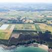
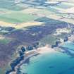
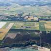
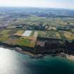
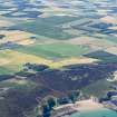
The 1968 edition of the OS 1:10560 map depicts what appears to be a roughly-rectangular area of quarrying set back into the sea cliff 1.8km WSW of Covesea village (NJ17SE 16).
The E part of the area indicated extends into the parish of Drainie, and the reported location of the cairn NJ17SE 5 falls within the area indicated.
Information from RCAHMS (RJCM), 16 March 2011.
Covesea Quarry
(disused) [NAT]
OS (GIS) MasterMap, March 2011.

