
Pricing Change
New pricing for orders of material from this site will come into place shortly. Charges for supply of digital images, digitisation on demand, prints and licensing will be altered.
Knowhead


Standing Stone(S) (Prehistoric)
Site Name Knowhead
Classification Standing Stone(S) (Prehistoric)
Alternative Name(s) Knowehead
Canmore ID 31013
Site Number NO25NE 5
NGR NO 29833 58236
Datum OSGB36 - NGR
Permalink http://canmore.org.uk/site/31013


- Council Angus
- Parish Lintrathen
- Former Region Tayside
- Former District Angus
- Former County Angus
Field Visit (9 August 1942)
This site was recorded as part of the RCAHMS Emergency Survey, undertaken by Angus Graham and Vere Gordon Childe during World War 2. The project archive has been catalogued during 2013-2014 and the material, which includes notebooks, manuscripts, typescripts, plans and photographs, is now available online.
Information from RCAHMS (GF Geddes) 2 December 2014.
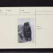
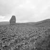
Note (1983)
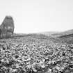
Knowehead NO 298 582 NO25NE 5
These two standing stones, one now recumbent, are situated at the E end of a low natural mound on the S-facing slope 260m S of Knowehead steading. The upright stone is 2.2m high, and the other is 2m long.
RCAHMS 1983.
(Name Book, Forfar, No. 62, p. 71).

