Accessibility

Font Size

100% 150% 200%

Background Colour

Default Contrast
Close Reset

Pricing Change

New pricing for orders of material from this site will come into place shortly. Charges for supply of digital images, digitisation on demand, prints and licensing will be altered. 


Creigh Hill, Cairn Motherie

Cairn (Prehistoric)

Site Name Creigh Hill, Cairn Motherie

Classification Cairn (Prehistoric)

Canmore ID 31006

Site Number NO25NE 3

NGR NO 27115 59346

Datum OSGB36 - NGR

Permalink http://canmore.org.uk/site/31006

Ordnance Survey licence number AC0000807262. All rights reserved.
Canmore Disclaimer. © Bluesky International Limited 2025. Public Sector Viewing Terms

Toggle Aerial | View on large map

Digital Images

Administrative Areas

  • Council Angus
  • Parish Lintrathen
  • Former Region Tayside
  • Former District Angus
  • Former County Angus

Activities

Note (1983)

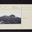
Creigh Hill 1 NO 271 593 NO25NE 3

This cairn, known as Cairn Motherie, is situated on the N summit of Creigh Hill (497m OD) and measures 13m in diameter by 1.2m in height.

RCAHMS 1983

(Name Book, Forfar, No. 62, p. 45; Coutts 1970, p. 9, no. 10).

References

MyCanmore Image Contributions


Contribute an Image

MyCanmore Text Contributions