Accessibility

Font Size

100% 150% 200%

Background Colour

Default Contrast
Close Reset

Unst, Underhoull

Broch (Iron Age)

Site Name Unst, Underhoull

Classification Broch (Iron Age)

Canmore ID 31

Site Number HP50SE 12

NGR HP 5746 0445

Datum OSGB36 - NGR

Permalink http://canmore.org.uk/site/31

Ordnance Survey licence number AC0000807262. All rights reserved.
Canmore Disclaimer. © Bluesky International Limited 2025. Public Sector Viewing Terms

Toggle Aerial | View on large map

Digital Images

Oblique aerial view of the Broch of Underhoull and the field systems, looking NNE.
Oblique aerial view of the Broch of Underhoull and the field systems, looking NNE.Oblique aerial view of the Broch of Underhoull and the field systems, looking SSW.Oblique aerial view of the Broch of Underhoull and the field systems, looking SE.Broch of Underhoull; the ditch
Oblique aerial view centred on the remains of the broch and field-system, taken from the SE.Unst, Underhoull, HP50SE 12, Ordnance Survey index card, RectoSection of Underhoull broch.Oblique aerial view centred on the remains of the broch and field-system, taken from the SSE.Settlement below broch.General view.
Inv. fig 658 RCAHMSUnst, Underhoull, HP50SE 12, Ordnance Survey index card, RectoPlane-table survey; Underhoull broch, plan of broch and outer defences, with reduced version (in red at 1":16')Oblique aerial view centred on the remains of the broch and field-system, taken from the ENE.Oblique aerial view centred on the remains of the broch and field-system with the remains of the settlement, souterrain and farmstead adjacent, taken from the NNE.Oblique aerial view of the Broch of Underhoull and the field systems, looking SSW.Oblique aerial view centred on the remains of the broch and field-system, taken from the NNW.Unst, Underhoull, HP50SE 12, Ordnance Survey index card, page number 2, VersoOblique aerial view of the Broch of Underhoull and the field systems, looking E.Oblique aerial view centred on the remains of the broch and field-system, taken from the SW.Unst, Underhoull, HP50SE 12, Ordnance Survey index card, RectoOblique aerial view of the Broch of Underhoull and the field systems, looking ENE.Oblique aerial view of the farmsteads, the Broch of Underhoull and the field systems, looking NE.Oblique aerial view centred on the remains of the broch and field-system, taken from the SSW.Unst, Underhoull, HP50SE 12, Ordnance Survey index card, page number 1, RectoPlane-table survey; Underhoull broch, plan of broch and outer defences, with reduced version (in a thicker line at 1":16'). Scanned image of photographic copy.Oblique aerial view of the Broch of Underhoull and the field systems, looking WSW.Publication drawing; plan and section, Underhoull broch.Oblique aerial view centred on the remains of the broch and field-system, taken from the NNE.Unst, Underhoull, HP50SE 12, Ordnance Survey index card, RectoPublication drawing; plan and section, Underhoull broch. Scanned image of photographic copy.Oblique aerial view of the Broch of Underhoull and the field systems, looking WSW.Outer Ramparts.View down from settlement.Unst, Underhoull, HP50SE 12, Ordnance Survey index card, VersoUnst, Underhoull, HP50SE 12, Ordnance Survey index card, Recto

Administrative Areas

  • Council Shetland Islands
  • Parish Unst
  • Former Region Shetland Islands Area
  • Former District Shetland
  • Former County Shetland

Archaeology Notes

HP50SE 12 5746 0445.

(HP 5745 0443) Brough (NR).

OS 6" map, Shetland, 2nd ed., (1900).

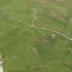
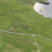
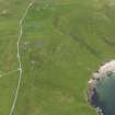
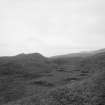
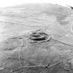
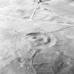
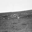
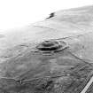
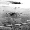
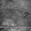
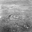
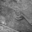
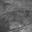
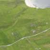
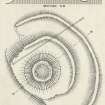
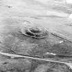
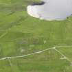
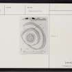
The broch of Underhoull or Overbrough has been almost entirely destroyed, but its position, on the top of a prominent knoll is clearly marked by the surviving traces of its defensive works.

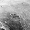
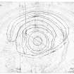
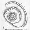
Although the walls have practically disappeared, surface indications show that the structure has been of normal type and probably about 55' in diameter over all, with a wall thickness of roughly 15'.

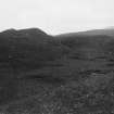
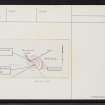
Outside for about half the circumference are two concentric ramparts of earth, with a wide intervening ditch, 9' in maximum depth, which has been levelled and brought under cultivation. The approach was apparently from the NW. Irvine (nd.) notes marks of an out-building beyond ditch on east side, perhaps later than Brough.

J T Irvine nd.; RCAHMS 1946, visited 1930.

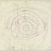
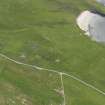
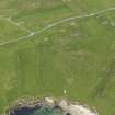
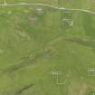
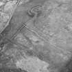
Broch of Underhoull as described by the RCAHMS. The broch has measured overall 17.2m E-W by 16.8m transverse- ly with the entrance visible in the SW. Part of the outer rampart has been destroyed on the S side by cultivation terraces. There are numerous field walls in the area, including one massive wall extending from the outer rampart in a S direction along the crest of the hill. Some are undoubtedly associated with the broch, some with nearby Viking occupation (HP50SE 1 and HP50SE 32 ), and some are comparatively recent, but it is impossible to differentiate between the various periods.

Re-surveyed at 1/2500.

Visited by OS(NKB) 5 May 1969

Activities

Publication Account (2002)

HP50 10 UNDERHOULL

HP/575044 (visited 7/6/63)

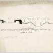
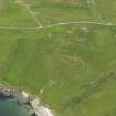
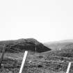
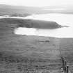
This probable broch on Unst stands on the edge of a ridge which slopes down with increasing shallowness to the (Ills. 4.1 (lower) and 4.3). The Commission considered that the broch itself, situated on a mound about 250m from the shore at Lunda Wick, has been almost entirely destroyed and that all that is left is under its own debris. Surface indications suggest that the broch has a diameter of 55 ft. with a wall c. 15 ft. thick [2]. Two concentric ramparts of earth surround the broch, forming a D-shaped enclosure and ending at the edge of the steep slope. A deep and wide ditch is between the banks (Ill. 4.3). Excavations have been carried out on the slope between the broch and the shore and the remains of an extensive settlement revealed [4].

Refs: 1. OS card HP 50 SE 12 (with sketch plan): 2. RCAHMS 1946, vol. 3, no. 1547, 133 and figs. 658 and 660: 3. Irvine 1865: 4. Small 1966.

NMR photographs: 2P, 1T.

E W MacKie 2002

References

MyCanmore Image Contributions


Contribute an Image

MyCanmore Text Contributions