
Pricing Change
New pricing for orders of material from this site will come into place shortly. Charges for supply of digital images, digitisation on demand, prints and licensing will be altered.
Stirling, King's Park, Stirling Golf Course


Golf Course (19th Century) (1869)
Site Name Stirling, King's Park, Stirling Golf Course
Classification Golf Course (19th Century) (1869)
Canmore ID 308641
Site Number NS79SE 889
NGR NS 78575 93402
NGR Description Centred on NS 78575 93402
Datum OSGB36 - NGR
Permalink http://canmore.org.uk/site/308641
Ordnance Survey licence number AC0000807262. All rights reserved.
Canmore Disclaimer.
© Bluesky International Limited 2025. Public Sector Viewing Terms
- Correction
- Favourite

DP 175986
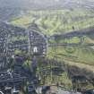
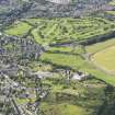
Oblique aerial view of the King's Knot, the King's Park and the golf course, looking SSW.
RCAHMS Aerial Photography Digital
7/2/2014
© Crown Copyright: HES

DP 176008
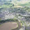
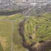
Oblique aerial view centred on part of the disused race course, the farmstead and the golf course, looking SSW.
RCAHMS Aerial Photography Digital
7/2/2014
© Crown Copyright: HES

DP 176024
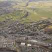
General oblique aerial view of the King's Park, the King's Knot, the golf course and the disused race course and Stirling Castle, looking ENE.
RCAHMS Aerial Photography Digital
7/2/2014
© Crown Copyright: HES

DP 329786
Oblique aerial view.
Historic Environment Scotland
16/3/2020
© Copyright: HES

DP 136210
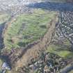
General oblique aerial view of Stirling Golf Course, taken from the SW.
RCAHMS Aerial Photography Digital
14/6/2012
© Crown Copyright: HES

DP 136211
General oblique aerial view of Stirling Golf Course, taken from the SSW.
RCAHMS Aerial Photography Digital
14/6/2012
© Crown Copyright: HES

DP 136215
Oblique aerial view of Stirling Golf Course, taken from the N.
RCAHMS Aerial Photography Digital
14/6/2012
© Crown Copyright: HES

DP 158718
General oblique aerial view looking towards Stirling Castle centred on the King's Park and Stirling golf course, looking to the N S.
RCAHMS Aerial Photography Digital
12/3/2013
© Crown Copyright: HES

DP 175967
General oblique aerial view of Stirling Golf Course, the King's Park and the disused race course with Stirling Castle beyond, looking NNE.
RCAHMS Aerial Photography Digital
7/2/2014
© Crown Copyright: HES

DP 175980
Oblique aerial view of part of the golf course, looking NNE.
RCAHMS Aerial Photography Digital
7/2/2014
© Crown Copyright: HES

DP 175985
Oblique aerial view of the King's Knot, the King's Park and the golf course, looking SSW.
RCAHMS Aerial Photography Digital
7/2/2014
© Crown Copyright: HES

DP 176004
Oblique aerial view centred on part of the disused race course, the farmstead and the golf course, looking NNW.
RCAHMS Aerial Photography Digital
7/2/2014
© Crown Copyright: HES

DP 176006
Oblique aerial view centred on part of the disused race course, the farmstead and the golf course, looking S.
RCAHMS Aerial Photography Digital
7/2/2014
© Crown Copyright: HES

DP 176010
Oblique aerial view centred on part of the disused race course, the farmstead and the golf course, looking SE.
RCAHMS Aerial Photography Digital
7/2/2014
© Crown Copyright: HES

DP 176014
General oblique aerial view of the King's Park, the King's Knot, the golf course, the farmstead and the disused race course, looking W.
RCAHMS Aerial Photography Digital
7/2/2014
© Crown Copyright: HES

DP 176023
General oblique aerial view of the King's Park, the King's Knot, the golf course and the disused race course and Stirling Castle, looking ESE.
RCAHMS Aerial Photography Digital
7/2/2014
© Crown Copyright: HES

DP 158719
General oblique aerial view looking towards Stirling Castle centred on the King's Park and Stirling golf course, looking to the N.
RCAHMS Aerial Photography Digital
12/3/2013
© Crown Copyright: HES

DP 175968
General oblique aerial view of Stirling Golf Course, the King's Park and the disused race course with Stirling Castle beyond, looking NNE.
RCAHMS Aerial Photography Digital
7/2/2014
© Crown Copyright: HES

DP 175969
General oblique aerial view of Stirling Golf Course, the King's Park and the disused race course with Stirling Castle beyond, looking E.
RCAHMS Aerial Photography Digital
7/2/2014
© Crown Copyright: HES

DP 175975
General oblique aerial view of Stirling Golf Course, the King's Park, the disused race course, the King's Knot and the dam, looking SSW.
RCAHMS Aerial Photography Digital
7/2/2014
© Crown Copyright: HES

DP 175977
Oblique aerial view of the dam, looking ENE.
RCAHMS Aerial Photography Digital
7/2/2014
© Crown Copyright: HES

DP 240574
Oblique aerial view.
Historic Environment Scotland
26/8/2016
© Copyright: HES

DP 329782
Oblique aerial view.
Historic Environment Scotland
16/3/2020
© Copyright: HES

DP 108496
General oblique aerial view of Stirling Castle and Stirling Golf Course, taken from the NNE.
RCAHMS Aerial Photography Digital
9/8/2011
© Crown Copyright: HES

DP 158720
Oblique aerial view centred on the King's Park and Stirling golf course, looking to the W.
RCAHMS Aerial Photography Digital
12/3/2013
© Crown Copyright: HES

DP 158721
Oblique aerial view looking centred on the King's Park and Stirling golf course, looking to the W.
RCAHMS Aerial Photography Digital
12/3/2013
© Crown Copyright: HES

DP 175982
Oblique aerial view of the dam, the disused race course and the golf course, looking W.
RCAHMS Aerial Photography Digital
7/2/2014
© Crown Copyright: HES

DP 175987
Oblique aerial view of the golf course and the disused race course, looking NW.
RCAHMS Aerial Photography Digital
7/2/2014
© Crown Copyright: HES

DP 176012
Oblique aerial view centred on part of the disused race course, the farmstead and the golf course, looking ESE.
RCAHMS Aerial Photography Digital
7/2/2014
© Crown Copyright: HES

DP 175971
General oblique aerial view of Stirling Golf Course, the King's Park and the disused race course with Stirling Castle beyond, looking NE.
RCAHMS Aerial Photography Digital
7/2/2014
© Crown Copyright: HES

DP 329780
Oblique aerial view.
Historic Environment Scotland
16/3/2020
© Copyright: HES

DP 114695
General oblique aerial view of King's Knot and Stirling Golf Course, taken from the N.
RCAHMS Aerial Photography Digital
15/2/2012
© Crown Copyright: HES

DP 158722
Oblique aerial view looking centred on the King's Park and Stirling golf course, looking to the SW.
RCAHMS Aerial Photography Digital
12/3/2013
© Crown Copyright: HES

DP 175964
General oblique aerial view of Stirling Golf Course, the King's Park and the disused race course, looking SSE.
RCAHMS Aerial Photography Digital
7/2/2014
© Crown Copyright: HES

DP 175970
General oblique aerial view of Stirling Golf Course, the King's Park and the disused race course with Stirling Castle beyond, looking ESE.
RCAHMS Aerial Photography Digital
7/2/2014
© Crown Copyright: HES

DP 175978
Oblique aerial view of the dam, looking E.
RCAHMS Aerial Photography Digital
7/2/2014
© Crown Copyright: HES

DP 175988
Oblique aerial view centred on part of the disused race course, the farmstead and the golf course, looking NNE.
RCAHMS Aerial Photography Digital
7/2/2014
© Crown Copyright: HES

DP 329781
Oblique aerial view.
Historic Environment Scotland
16/3/2020
© Copyright: HES

DP 329796
Oblique aerial view.
Historic Environment Scotland
16/3/2020
© Copyright: HES

DP 114696
General oblique aerial view of King's Knot and Stirling Golf Course, taken from the N.
RCAHMS Aerial Photography Digital
15/2/2012
© Crown Copyright: HES

DP 136209
Oblique aerial view of Stirling Golf Course, taken from the W.
RCAHMS Aerial Photography Digital
14/6/2012
© Crown Copyright: HES

DP 136213
Oblique aerial view of Stirling Golf Course, taken from the ENE.
RCAHMS Aerial Photography Digital
14/6/2012
© Crown Copyright: HES

DP 136214
Oblique aerial view of Stirling Golf Course, taken from the N.
RCAHMS Aerial Photography Digital
14/6/2012
© Crown Copyright: HES

DP 175972
Oblique aerial view of Stirling Golf Course, the King's Park, the disused race course, the King's Knot and the dam, looking W.
RCAHMS Aerial Photography Digital
7/2/2014
© Crown Copyright: HES

DP 175973
Oblique aerial view of Stirling Golf Course, the King's Park, the disused race course and the dam, looking SW.
RCAHMS Aerial Photography Digital
7/2/2014
© Crown Copyright: HES

DP 175989
Oblique aerial view of the golf course, the farmstead and the disused race course, looking N.
RCAHMS Aerial Photography Digital
7/2/2014
© Crown Copyright: HES

DP 175991
Oblique aerial view centred on part of the disused race course, the farmstead and the golf course, looking WNW.
RCAHMS Aerial Photography Digital
7/2/2014
© Crown Copyright: HES

DP 176005
Oblique aerial view centred on part of the disused race course, the farmstead and the golf course, looking N.
RCAHMS Aerial Photography Digital
7/2/2014
© Crown Copyright: HES

DP 176015
Oblique aerial view of the King's Park, the golf course, the disused race course and the dam, looking WNW.
RCAHMS Aerial Photography Digital
7/2/2014
© Crown Copyright: HES

DP 176026
General oblique aerial view of the King's Park, the disused race course and the golf course, with the King's Knot and Stirling Castle beyond, looking NNW.
RCAHMS Aerial Photography Digital
7/2/2014
© Crown Copyright: HES

DP 108497
General oblique aerial view of Stirling Castle and Stirling Golf Course, taken from the NNE.
RCAHMS Aerial Photography Digital
9/8/2011
© Crown Copyright: HES

DP 114694
General oblique aerial view of King's Knot and Stirling Golf Course, taken from the N.
RCAHMS Aerial Photography Digital
15/2/2012
© Crown Copyright: HES

DP 175965
General oblique aerial view of Stirling Golf Course, the King's Park and the disused race course, looking SSE.
RCAHMS Aerial Photography Digital
7/2/2014
© Crown Copyright: HES

DP 175984
Oblique aerial view of the dam, the disused race course and the golf course, looking W.
RCAHMS Aerial Photography Digital
7/2/2014
© Crown Copyright: HES

DP 329779
Oblique aerial view.
Historic Environment Scotland
16/3/2020
© Copyright: HES

DP 136212
Oblique aerial view of Stirling Golf Course, taken from the E.
RCAHMS Aerial Photography Digital
14/6/2012
© Crown Copyright: HES

DP 175981
Oblique aerial view of the dam, looking NE.
RCAHMS Aerial Photography Digital
7/2/2014
© Crown Copyright: HES

DP 175992
Oblique aerial view centred on part of the disused race course, the farmstead and the golf course, looking W.
RCAHMS Aerial Photography Digital
7/2/2014
© Crown Copyright: HES

DP 175999
Oblique aerial view of part of the golf course and the disused race course, looking ENE.
RCAHMS Aerial Photography Digital
7/2/2014
© Crown Copyright: HES

DP 176009
Oblique aerial view centred on part of the disused race course, the farmstead and the golf course, looking SSE.
RCAHMS Aerial Photography Digital
7/2/2014
© Crown Copyright: HES

DP 176028
General oblique aerial view of the King's Park, the disused race course and the golf course, with the King's Knot and Stirling Castle beyond, looking N.
RCAHMS Aerial Photography Digital
7/2/2014
© Crown Copyright: HES


- Council Stirling
- Parish Stirling
- Former Region Central
- Former District Stirling
- Former County Stirlingshire

