
Pricing Change
New pricing for orders of material from this site will come into place shortly. Charges for supply of digital images, digitisation on demand, prints and licensing will be altered.
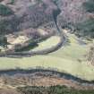
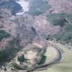
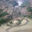
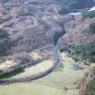
Scatwell Farm


Building (Period Unassigned), Dam (Period Unassigned)
Site Name Scatwell Farm
Classification Building (Period Unassigned), Dam (Period Unassigned)
Alternative Name(s) Glascharn
Canmore ID 308454
Site Number NH35NE 43
NGR NH 3929 5634
Datum OSGB36 - NGR
Permalink http://canmore.org.uk/site/308454


- Council Highland
- Parish Contin
- Former Region Highland
- Former District Ross And Cromarty
- Former County Ross And Cromarty
Field Visit (6 February 2007 - 6 February 2007)
A township, buildings and dams (NOSAS site survey Nos 131 – 133, 138 – 143) centred on NH 3929 5634 is located some 200m W of Scatwell Farm. The remains of three turf buildings (138 140) located on the margins of grass land and marsh. A series of three dams and ponds (131 – 133) are also included in this record.
Scatwell Farm is depicted as a courtyard farmstead and named as Glascharn on 1st edition of the OS 6-inch map (Ross-shire 1881, sheet lxxxvi) and may be one of the settlements shown on the Roy map of c.1750.
Further details of these and other associated sites can be found in the Strathconon Phase 1 Report (pages 51-52) produced by the North of Scotland Archaeology Society and appended to this record.

