
Blackadder Mount, Pump House, Lade


Lade (Period Unassigned)
Site Name Blackadder Mount, Pump House, Lade
Classification Lade (Period Unassigned)
Canmore ID 307451
Site Number NT85SW 68.01
NGR NT 84866 53829
NGR Description From NT84817 53804 to 84901 53854
Datum OSGB36 - NGR
Permalink http://canmore.org.uk/site/307451


- Council Scottish Borders, The
- Parish Edrom
- Former Region Borders
- Former District Berwickshire
- Former County Berwickshire
Note (16 April 2010)
Survey carried out as an addition to the National Record. This pump has been earmarked for dismantling and re-use at another site.
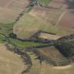
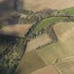
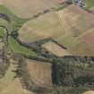
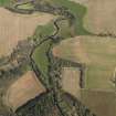
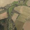
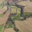
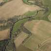
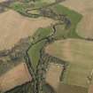
This lade, which runs from NT84817 53804 to 84901 53854 (a distance of some 100 metres) fed water to the Blackadder House Pump House pump (NT85SW 68.05) which in turn pumped water to the walled garden (NT85SW 68.01). The lade is depicted but not named on the 2nd edition Ordnance Survey 6-inch map (Berwickshire, 1909, sheet XVII) but is not depicted on the 1st edition Ordnance Survey 6-inch map (Berwickshire, 1862, sheet XVII).
Information from RCAHMS (MMD), 16 April 2010.

