
Hoy, South Burn Of Quoys


Quarry (Period Unassigned)
Site Name Hoy, South Burn Of Quoys
Classification Quarry (Period Unassigned)
Canmore ID 307346
Site Number HY20SW 44
NGR HY 2385 0310
Datum OSGB36 - NGR
Permalink http://canmore.org.uk/site/307346


- Council Orkney Islands
- Parish Hoy And Graemsay
- Former Region Orkney Islands Area
- Former District Orkney
- Former County Orkney
HY20SW 44 2385 0310
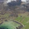
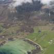
An infilled quarry is recorded on oblique aerial photography (RCAHMSAP 2009) immediately to the SW of the road at Quoys.
Information from RCAHMS (LMcC) 10 November 2010

