
Rousay, Flanders Moss


Farmstead (Post Medieval), Sheepfold (Post Medieval)
Site Name Rousay, Flanders Moss
Classification Farmstead (Post Medieval), Sheepfold (Post Medieval)
Alternative Name(s) Scar
Canmore ID 307299
Site Number HY32NE 87
NGR HY 3887 2905
NGR Description Centred HY 3887 2905
Datum OSGB36 - NGR
Permalink http://canmore.org.uk/site/307299


- Council Orkney Islands
- Parish Rousay And Egilsay
- Former Region Orkney Islands Area
- Former District Orkney
- Former County Orkney
HY32NE 87 3887 2905
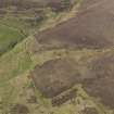
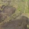
The remains of this farmstead are recorded on oblique aerial photographs (RCAHMSAP 2009). A farmstead comprising three roofed buildings is depicted on the 1st edition of the OS 6-inch map (Orkney) 1882, lxxxix). A large, circular sheepfold is situated about 100m to the ESE.
Information from RCAHMS (LMcC), 4 October 2010.

