
Rousay, Hillycliff


Farmstead (Period Unassigned)
Site Name Rousay, Hillycliff
Classification Farmstead (Period Unassigned)
Canmore ID 307298
Site Number HY32NE 86
NGR HY 3869 2925
Datum OSGB36 - NGR
Permalink http://canmore.org.uk/site/307298


- Council Orkney Islands
- Parish Rousay And Egilsay
- Former Region Orkney Islands Area
- Former District Orkney
- Former County Orkney
HY32NE 86 3869 2925
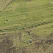
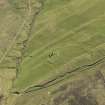
The remains of this farmstead are situated on the N bank of an unnamed burn at Hillycliff and are recorded on oblique aerial photographs (RCAHMSAP 2009). Comprising the ruins of a stone buidling and single enclosure, both are depicted on the on the 1st edition of the OS 6-inch map (Orkney 1882, lxxxix); the building is shown as roofed. The footprint of another what may be a rectangular buidling and enclosure lie about 70m SW of the farmstead but is not recorded on the OS 1st edition map.
Information from RCAHMS (LMcC) 4 November 2010

