
Pricing Change
New pricing for orders of material from this site will come into place shortly. Charges for supply of digital images, digitisation on demand, prints and licensing will be altered.
Ellon, Wateridgemuir


Mill Pond (Period Unassigned)
Site Name Ellon, Wateridgemuir
Classification Mill Pond (Period Unassigned)
Canmore ID 306308
Site Number NJ92NE 128.02
NGR NJ 9538 2646
Datum OSGB36 - NGR
Permalink http://canmore.org.uk/site/306308


- Council Aberdeenshire
- Parish Logie Buchan
- Former Region Grampian
- Former District Gordon
- Former County Aberdeenshire
Note (7 October 2007)
Mill Pond
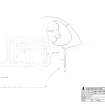
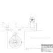
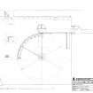
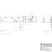
The mill pond sits to the N of Wateridgemuir steading (see NJ92NE 128.00) and is depicted on the Ordnance Survey 1st edition 25-inch map (Aberdeen, 1867-68, sheet XLVII.7). It is shown as measuring 38.0m on the N-S axis by 53.5m on its W-E axis and has rubble, stone-lined sides. The site was recorded in advance of conversion to dwellings and the ‘soft filling’ of the waterwheel pit.
The close proximity of the mill pond to the steading suggests that any head that the pond could provide was limited, hence the underground waterwheel adjacent to what was latterly the milking area (currently unroofed) to increase the gravity of any water flowing from the pond to the machinery. The pond is now much silted up (see DC48442) and the sluice nearest the underground wheel was not identified during the RCAHMS survey. However, from map evidence, the probable sluice position was at NJ95388 26460. The water was carried underground, presumably at a slight angle to built up kinetic energy, for approximately 24.0m to NJ9540 2644 where the water was carried to the wheel by a wooden pentrough or launder within the wheel pit.
Visited by RCAHMS (MMD, JB, HS), October 2007.

