
Huttonburn Bridge


Drain(S) (Period Unassigned)
Site Name Huttonburn Bridge
Classification Drain(S) (Period Unassigned)
Canmore ID 305991
Site Number NO10SW 157
NGR NO 1292 0509
Datum OSGB36 - NGR
Permalink http://canmore.org.uk/site/305991


- Council Perth And Kinross
- Parish Orwell
- Former Region Tayside
- Former District Perth And Kinross
- Former County Kinross-shire
NO10SW 157 1292 0509
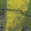
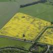
Parallel ditches, which are probably drains, have been recorded as cropmarks on obliques aerial photographs (RCAHMSAP 2008) in a slight hollow near Huttonburn Bridge.
Information from RCAHMS (DCC) 23 August 2010

