
Pricing Change
New pricing for orders of material from this site will come into place shortly. Charges for supply of digital images, digitisation on demand, prints and licensing will be altered.
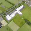
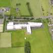
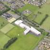
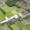
Bo'ness, Grahamsdyke, Gauze Road, The Academy


School (21st Century)
Site Name Bo'ness, Grahamsdyke, Gauze Road, The Academy
Classification School (21st Century)
Alternative Name(s) Bo'ness Academy
Canmore ID 305728
Site Number NT08SW 159
NGR NT 00429 80809
Datum OSGB36 - NGR
Permalink http://canmore.org.uk/site/305728


- Council Falkirk
- Parish Bo'ness And Carriden
- Former Region Central
- Former District Falkirk
- Former County West Lothian
NT08SW 159 00429 80809
The Academy [NAT]
OS (GIS) MasterMap, August 2010.
Characterisation
This site falls within the Gauze Road Area of Townscape Character (NT08SW 164), which was defined as part of the RCAHMS Urban Survey Programme 2013. Text relating to the historical development and topography, and present character of the Gauze Road Area of Townscape Character can be viewed at site NT08SW 164.
Information from RCAHMS (LK), January 2014

