
Bute, Barone Park


Farmstead (Period Unassigned)
Site Name Bute, Barone Park
Classification Farmstead (Period Unassigned)
Canmore ID 305051
Site Number NS06SE 440
NGR NS 07991 63658
Datum OSGB36 - NGR
Permalink http://canmore.org.uk/site/305051


- Council Argyll And Bute
- Parish North Bute
- Former Region Strathclyde
- Former District Argyll And Bute
- Former County Buteshire
NS06SE 440 07991 63658
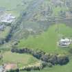
Barone Park is a working farmsteading that comprises a mixture of 19th century buildings and large modern sheds, which was not recorded on the date of visit. ‘Barrone Park’ is depicted as two buildings on a mid-18th century estate map (Foulis 1758-9), and a later estate map (May 1780-82) shows three buildings and a yard, detailed in a contemporary inventory (May et al 1782-1827). The 1st edition of the OS 6-inch map (Buteshire 1869, Sheet CCIV) depicts six roofed buildings, those at the E end later developing into a courtyard that shown on the 2nd edition of the map (Buteshire 1869, Sheet CCIV.SW).
Visited by RCAHMS (GFG, AGCH) 20 April 2009.
Antiquarian Mapping (1758 - 1759)
Antiquarian Mapping (1781)
Reference (1782 - 1814)

