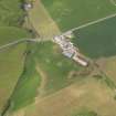
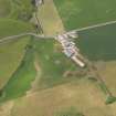
Accessibility

Font Size

100% 150% 200%

Background Colour

Default Contrast
Close Reset

Low Smerby

Farmhouse (Period Unassigned), Farmstead (Period Unassigned)

Site Name Low Smerby

Classification Farmhouse (Period Unassigned), Farmstead (Period Unassigned)

Canmore ID 305022

Site Number NR72SE 23

NGR NR 75406 22933

Datum OSGB36 - NGR

Permalink http://canmore.org.uk/site/305022

Ordnance Survey licence number AC0000807262. All rights reserved.
Canmore Disclaimer. © Bluesky International Limited 2025. Public Sector Viewing Terms

Toggle Aerial | View on large map

Digital Images

Oblique aerial view centred on the parchmarks of the pits at Low Smerby, taken from the SE.
Oblique aerial view centred on the parchmarks of the pits at Low Smerby, taken from the SE.Oblique aerial view centred on the parchmarks of the pits at Low Smerby, taken from the ESE.

Collections

Administrative Areas

  • Council Argyll And Bute
  • Parish Campbeltown
  • Former Region Strathclyde
  • Former District Argyll And Bute
  • Former County Argyll

References

MyCanmore Image Contributions


Contribute an Image

MyCanmore Text Contributions