
Pricing Change
New pricing for orders of material from this site will come into place shortly. Charges for supply of digital images, digitisation on demand, prints and licensing will be altered.
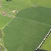
Doo Hill


Enclosure (Period Unknown)
Site Name Doo Hill
Classification Enclosure (Period Unknown)
Canmore ID 304861
Site Number NJ26SE 132
NGR NJ 2675 6961
Datum OSGB36 - NGR
Permalink http://canmore.org.uk/site/304861


- Council Moray
- Parish St Andrews-lhanbryd
- Former Region Grampian
- Former District Moray
- Former County Morayshire
NJ26SE 132 2675 6061
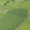
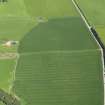
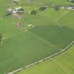
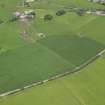
What may be a large irregular enclosure with a broad ditch has been recorded as cropmarks on oblique aerial photographs (RCAHSMAP 2008) on the summit of Doo Hill.
Information from RCAHMS (DCC) 1 July 2010
Aerial Photography

