
Pricing Change
New pricing for orders of material from this site will come into place shortly. Charges for supply of digital images, digitisation on demand, prints and licensing will be altered.
Ballinbreich Castle, Chapel


Chapel (14th Century)
Site Name Ballinbreich Castle, Chapel
Classification Chapel (14th Century)
Alternative Name(s) Chapel Hill; Chapel Of Glenduchie; Ballinbreich Castle Policies; Glenduckie
Canmore ID 30464
Site Number NO22SE 10
NGR NO 2726 2052
Datum OSGB36 - NGR
Permalink http://canmore.org.uk/site/30464


- Council Fife
- Parish Flisk
- Former Region Fife
- Former District North East Fife
- Former County Fife
NO22SE 10 2726 2052
(NO 2726 2052) Chapel (NR) (Site of)
OS 6" map (1921)
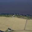
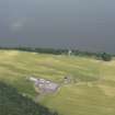
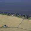
Traditionally a chapel formerly stood on Chapel Hill, E of Ballinbreich Castle (NO22SE 8.00), and it is very likely that this was the chapel of Glenduchie, which is mentioned in various charters between 1450 and 1682. Its foundations could still be traced in 1845.
A H Millar 1895; NSA 1845 (G Marshall)
A level area at the top of the slope to the Tay may represent the site of the chapel. There are boulders embedded at random in the ground here, but they appear to be more likely to be the result of field clearance than the remains of a building. The OS siting is considered unlikely, being on a fairly steep slope, with no trace of levelling.
Visited by OS (WDJ) 19 May 1970.

