
Following the launch of trove.scot in February 2025 we are now planning the retiral of some of our webservices. Canmore will be switched off on 24th June 2025. Information about the closure can be found on the HES website: Retiral of HES web services | Historic Environment Scotland
Castle Howe


Castle (Norse), Settlement (Later Prehistoric)
Site Name Castle Howe
Classification Castle (Norse), Settlement (Later Prehistoric)
Canmore ID 3044
Site Number HY50SW 13
NGR HY 5138 0030
Datum OSGB36 - NGR
Permalink http://canmore.org.uk/site/3044


- Council Orkney Islands
- Parish Holm
- Former Region Orkney Islands Area
- Former District Orkney
- Former County Orkney
HY50SW 13 5138 0030.
(HY 51380030) Castle Howe Brough (NR)
OS 6"map, Orkney, 2nd ed.,(1903).
Castle Howe (NR)
OS 25"map, Orkney, 1st ed.,(1881).
Castle Howe: This early domestic Structure was excavated a few years before 1933 and revealed dry built walls enclosing two chambers, one above theother, and of distinct periods. The lower chamber appears to be prehistoric, its walls survive to a height of 5ft. 3 ins; the stairs may be original, the quern shown on the plan has been set to form an upright, and the opening in the east has been filled in.
The upper building is of quite uncertain date and incorporates the lower; the walls are 6-7ft thick and the inside of the east wall has been recessed to a depth of 4ft towards its south end.
RCAHMS 1946, visited 12 July 1933.
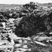
This domestic structure, situated on top of a grass covered mound known as Castle Howe was excavated between 1929 and 1931 by the Rev P B Clayton,who erected a protective wall around it (Information from Mr Tait, Lower Breckquoy, Holm, Orkney). The floor of the lower D-shaped chamber is 2.6m below ground level and is entered by a flight of stone steps, apparently contemporary from the west. The walls survive to a maximum height of 2.0m but no trace could be found of the upright quern mentioned by RCAHMS 1946. Above this chamber and incorporating it there is a rectangular dry stone construction maximum height of 1.0m of a later date whose entrance is at the same point as the original.
Although situated on a typical broch site there is no evidence of any circular construction on this mound.
Visited by OS(NKB) 28 August 1964.
Note (3 September 1930)
‘Tubby’ Clayton's Castle.
'The Rev. P. B. Clayton - Tubby to the Toc H. members - and Mr J. Storer Clouston, who wrote ‘The Lunatic at Large’, have unearthed a castle in Orkney where Mr Storer Clouston is a considerable laird, says ‘Quex’, in the ‘News Chronicle’. He and Mr Clayton came upon some promising ruins at Castle Howe, in Holm, at the south end of Pomona, and naturally, as ‘Tubby’ has been ordered north for a rest cure, they began excavating at once. In the hope that they were on the track of a Pictish broch they dug into a mound to be disappointed with ‘a medieval ring’. That is how Mr Storer Clouston puts it'.
Orkney Herald, and Weekly Advertiser and Gazette for the Orkney & Zetland Islands (3 September 1930, p.4).
Field Visit (12 July 1933)
Close to the beach, a little over a quarter of a mile to S.E. of the parish church of Holm and about the same distance S.W. of the farm of Lower Breckquoy, a mound covering remains of masonry was opened a few years ago. The excavation exposed dry-built walls enclosing two chambers, one above the other, obviously belonging to different periods.
The lower and earlier of the two (Fig. 428),which seems to be of prehistoric construction, is irregularly oval on plan, measuring approximately 14 ft. from E. to W. by 9 ft. from N. to S. Its walls still survive to a height of 5 ft. 3 in., and their inner faces, which alone are visible, show a pronounced batter. On the S.E. a flight of six rough steps leads down to the floor-level, and the prolongation of the S. wall as far as the head of these, along with a return of the wall immediately N. of them, suggests that the stair may be original. Most of the portion of the chamber N. of the steps has been cut off by a stone slab set on edge. This slab does not quite reach the N. wall, but beyond it a saddle quern has been set up to form an upright, while two other uprights farther E. may have been supports for a covering-slab, which could easily have rested partly on them and partly on a ledge constructed on the N. wall. There has been an opening in the E. end of the chamber; but, as is indicated by a race-bond rising the whole height of the S. wall, this has subsequently been filled in, no doubt during the erection of the upper building, which appears to have incorporated the chamber below. The original structure has certain points of resemblance to that excavated at Westness, Rousay (No. 580).
The upper building, which lies E. and W., is rectangular on plan, measuring some 32 ft. in length by 26 ft. in width, over walls which are from 6 to 7 ft. thick and are particularly rough and irregular on the outside. They have been tidied up and heightened in the process of excavation, but the few courses of original masonry that remain display a character differing from that of the building below; the courses of rubble are deeper and the stones used are more rounded. The only opening is a rough entrance in the W. wall. It has been rebuilt, but at present it is 3 ft. wide outside, increasing to 7 ft. wide inside, and there are three downward steps in its course. The inside of the E. wall has been recessed to a depth of4 ft. towards its S. end. The age of this later structure is quite uncertain.
RCAHMS 1946, visited 12 July 1933.
OS 6” map (1903)
Measured Survey (1933)
Surveyed to produce plans of the upper and lower levels exposed in excavation, and a sketch section. Redrawn in ink and published at a reduced scale (RCAHMS 1946, fig. 154).
Orkney Smr Note (May 1979)
Recently discovered castle-square keep, its masonry showing traces of lime mortar, on a stone motte the nucleus of which is an earlier building. [R1]
Perhaps built by Hakon the Elder. [R2]
Recent excavations exposed two chambers, superimposed lower and earlier is prehistoric, irregular, walls of which only inner faces visible, are 5ft 3in high and have pronounced batter. Six steps down in SE corner. Opening at E end, blocked, presumably during building of upper structure which is rectangular, 32 x
26ft ext., wall thickness 6-7ft. Entrance in W wall. Inside of E wall recessed near S end. Age uncertain. [R3]
Domestic structure on top of mound excavated 1929-31 by Rev P B Clayton who erected a protective wall around it.
Generally as described but not all features mentioned by RCAMS now visible. No trace of any circular construction which might be a broch.
OS visit Aug 1964.
Field Visit (May 1979)
Badly deteriorated since OS visit; steps not visible, centre largely rubble-filled, curved wall of lower structure visible only in NW corner. Seems to be interior scarcement on S wall of upper structure. W wall broken down, entrance unclear. Traces of cement repairs to outer wall-face. - Indubitably a Norse castle, possibly related to bu of Papuli. Cf OR 82
Information from Orkney SMR (RGL) May 79.

