
Following the launch of trove.scot in February 2025 we are now planning the retiral of some of our webservices. Canmore will be switched off on 24th June 2025. Information about the closure can be found on the HES website: Retiral of HES web services | Historic Environment Scotland
Edinburgh, Baird Road, Ratho Villa


Villa (Period Unassigned)
Site Name Edinburgh, Baird Road, Ratho Villa
Classification Villa (Period Unassigned)
Alternative Name(s) Kirktonhill
Canmore ID 303284
Site Number NT17SW 260
NGR NT 13794 70974
Datum OSGB36 - NGR
Permalink http://canmore.org.uk/site/303284


- Council Edinburgh, City Of
- Parish Ratho
- Former Region Lothian
- Former District City Of Edinburgh
- Former County Midlothian
NT17SW 260 13794 70974
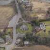
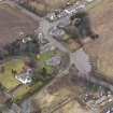
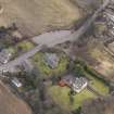
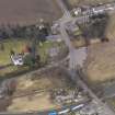
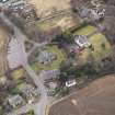
The former Ratho Villa has been identified from oblique aerial views (RCAHMSAP 2010), immediatey W of St Mary's Church.
The building is annotated as 'Ratho Villa' on the 1st Edition of the OS 25-inch map (Edinburghshire, 1852), and all subsequent 25-inch Editions. The current OS digital map annotates the building as 'Kirktonhill' and shows a different ground plan to that of the earlier OS editions.
Information from RCAHMS (DE), April 2010

