 |
On-line Digital Images |
SC 454965 |
Papers of Professor John R Hume, economic and industrial historian, Glasgow, Scotland |
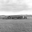
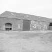
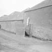
Reedieleys, FarmStead
General view showing gin-house |
2/9/1975 |
Item Level |
|
|
Photographs and Off-line Digital Images |
G 88748 CS |
RCAHMS Aerial Photography |
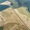
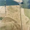
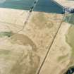
Oblique aerial view centred on the cropmarks of the pit-defined cursus, pits and rig, with farmhouse, pits, rig, ring-ditch and possible quarry adjacent, taken from the NW. |
16/7/2003 |
Item Level |
|
|
Photographs and Off-line Digital Images |
E 36751 |
RCAHMS Aerial Photography |
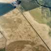
Oblique aerial view centred on the cropmarks of the pit-defined cursus, pits and rig, with farmhouse, pits, rig, ring-ditch and possible quarry adjacent, taken from the W. |
16/7/2003 |
Item Level |
|
|
Photographs and Off-line Digital Images |
E 40284 CN |
RCAHMS Aerial Photography |
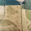
Oblique aerial view centred on the cropmarks of the pit-defined cursus, pits and rig, with farmhouse, pits, rig, ring-ditch and possible quarry adjacent, taken from the WNW. |
16/7/2003 |
Item Level |
|
|
Photographs and Off-line Digital Images |
E 40285 CN |
RCAHMS Aerial Photography |
Oblique aerial view centred on the cropmarks of the pit-defined cursus, pits and rig, with farmhouse, pits, rig, ring-ditch and possible quarry adjacent, taken from the W. |
16/7/2003 |
Item Level |
|
|
Photographs and Off-line Digital Images |
E 40286 CN |
RCAHMS Aerial Photography |
Oblique aerial view centred on the cropmarks of the pit-defined cursus, pits and rig, with farmhouse, pits, rig, ring-ditch and possible quarry adjacent, taken from the WSW. |
16/7/2003 |
Item Level |
|
|
Photographs and Off-line Digital Images |
E 40295 CN |
RCAHMS Aerial Photography |
Oblique aerial view centred on the cropmarks of the pit-defined cursus, pits and rig, with farmhouse, pits, rig, ring-ditch and possible quarry adjacent, taken from the NW. |
16/7/2003 |
Item Level |
|
|
Photographs and Off-line Digital Images |
E 40296 CN |
RCAHMS Aerial Photography |
Oblique aerial view centred on the cropmarks of the pit-defined cursus, pits and rig, with farmhouse, pits, rig, ring-ditch and possible quarry adjacent, taken from the W. |
16/7/2003 |
Item Level |
|
 |
On-line Digital Images |
SC 1712190 |
RCAHMS Aerial Photography |
Oblique aerial view centred on the cropmarks of the pit-defined cursus, pits and rig, with farmhouse, pits, rig, ring-ditch and possible quarry adjacent, taken from the W. |
16/7/2003 |
Item Level |
|
 |
On-line Digital Images |
SC 1712194 |
RCAHMS Aerial Photography |
Oblique aerial view centred on the cropmarks of the pit-defined cursus, pits and rig, with farmhouse, pits, rig, ring-ditch and possible quarry adjacent, taken from the WNW. |
16/7/2003 |
Item Level |
|
 |
On-line Digital Images |
SC 1712195 |
RCAHMS Aerial Photography |
Oblique aerial view centred on the cropmarks of the pit-defined cursus, pits and rig, with farmhouse, pits, rig, ring-ditch and possible quarry adjacent, taken from the W. |
16/7/2003 |
Item Level |
|
 |
On-line Digital Images |
SC 1712196 |
RCAHMS Aerial Photography |
Oblique aerial view centred on the cropmarks of the pit-defined cursus, pits and rig, with farmhouse, pits, rig, ring-ditch and possible quarry adjacent, taken from the WSW. |
16/7/2003 |
Item Level |
|
 |
On-line Digital Images |
SC 1712205 |
RCAHMS Aerial Photography |
Oblique aerial view centred on the cropmarks of the pit-defined cursus, pits and rig, with farmhouse, pits, rig, ring-ditch and possible quarry adjacent, taken from the NW. |
16/7/2003 |
Item Level |
|
 |
On-line Digital Images |
SC 1712206 |
RCAHMS Aerial Photography |
Oblique aerial view centred on the cropmarks of the pit-defined cursus, pits and rig, with farmhouse, pits, rig, ring-ditch and possible quarry adjacent, taken from the W. |
16/7/2003 |
Item Level |
|
 |
On-line Digital Images |
SC 1845648 |
Scottish Development Department |
Reedielays Steading, Auchtermuchty Parish, Strathclyde |
3/1981 |
Item Level |
|
 |
On-line Digital Images |
SC 1845649 |
Scottish Development Department |
Reedielays Steading, Auchtermuchty Parish, Strathclyde |
3/1981 |
Item Level |
|
 |
On-line Digital Images |
SC 2400826 |
Records of the Ordnance Survey, Southampton, Hampshire, England |
Reedieleys, NO21SW 118, Ordnance Survey index card, Recto |
c. 1958 |
Item Level |
|


