
Glasgow, Rutherglen, Gallowflat, M74 Extension, Carmyle To Polmadie Section


Motorway (21st Century)
Site Name Glasgow, Rutherglen, Gallowflat, M74 Extension, Carmyle To Polmadie Section
Classification Motorway (21st Century)
Canmore ID 302358
Site Number NS66SW 990
NGR NS 61858 61863
NGR Description From NS 64227 62338 to NS 60000 62478
Datum OSGB36 - NGR
Permalink http://canmore.org.uk/site/302358
Ordnance Survey licence number AC0000807262. All rights reserved.
Canmore Disclaimer.
© Bluesky International Limited 2025. Public Sector Viewing Terms
- Correction
- Favourite

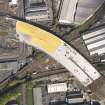
DP 063013
Oblique aerial view of the M74 extension centred on the junction with the M8 at the Kingston Bridge, taken from the SW.
RCAHMS Aerial Photography Digital
2/8/2009
© Crown Copyright: HES

DP 071964
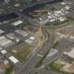
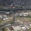
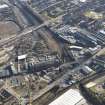
Oblique aerial view centred on the M74 extension work, Rutherglen area, taken from the ESE.
RCAHMS Aerial Photography Digital
26/6/2009
© Crown Copyright: HES

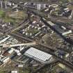
DP 072189
Oblique aerial view centred on the motorway extension works, taken from the SE.
RCAHMS Aerial Photography Digital
26/6/2009
© Crown Copyright: HES

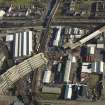
DP 072218
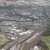
General oblique aerial view centred on the steel works with the motorway extension works adjacent, taken from the E.
RCAHMS Aerial Photography Digital
26/6/2009
© Crown Copyright: HES

DP 072230
General oblique aerial view centred on the steel works with the motorway extension works adjacent, taken from the NE.
RCAHMS Aerial Photography Digital
26/6/2009
© Crown Copyright: HES

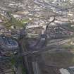
DP 075315
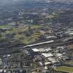
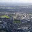
General oblique aerial view of Glasgow showing the route of the M74 extension going through the Rutherglen area, taken from the ENE.
RCAHMS Aerial Photography Digital
12/2/2010
© Crown Copyright: HES

DP 075322
Oblique aerial view of the city showing the route of the M74 extension going through the Rutherglen to Polamadie area centred on Power Motive Works, taken from the ESE.
RCAHMS Aerial Photography Digital
12/2/2010
© Crown Copyright: HES

DP 075343
Oblique aerial view of the M74 extension going through the Port Eglinton area to the M74 centred on Kilbirnie Street bridge, taken from the NW.
RCAHMS Aerial Photography Digital
12/2/2010
© Crown Copyright: HES

DP 088401
Oblique aerial view of the city showing the route of the M74 extension going from the Polmadie area to Dalbeth bridge centred on the Power Motive Works, taken from the W..
RCAHMS Aerial Photography Digital
4/10/2010
© Crown Copyright: HES

DP 153783
General oblique aerial view of Glasgow centred on the M74 extension at Rutherglen, looking to the W.
RCAHMS Aerial Photography Digital
17/5/2013
© Crown Copyright: HES

DP 071960
Oblique aerial view of motor way extension (Rutherglen section), taken from the NE.
RCAHMS Aerial Photography Digital
26/6/2009
© Crown Copyright: HES

DP 071988
General oblique aerial view centred on the motorway extension works with the railway station adjacent, taken from the WSW.
RCAHMS Aerial Photography Digital
26/6/2009
© Crown Copyright: HES

DP 071989
General oblique aerial view centred on the motorway extension works, taken from the SW.
RCAHMS Aerial Photography Digital
26/6/2009
© Crown Copyright: HES

DP 072201
Oblique aerial view centred on the motorway extension works, taken from the E.
RCAHMS Aerial Photography Digital
26/6/2009
© Crown Copyright: HES

DP 072206
General oblique aerial view centred on the motorway extension works, taken from the SE.
RCAHMS Aerial Photography Digital
26/6/2009
© Crown Copyright: HES

DP 072214
Oblique aerial view centred on the steel works, taken from the SSE.
RCAHMS Aerial Photography Digital
26/6/2009
© Crown Copyright: HES

DP 072227
General oblique aerial view centred on the steel works with the motorway extension works adjacent, taken from the NE.
RCAHMS Aerial Photography Digital
26/6/2009
© Crown Copyright: HES

DP 075317
Oblique aerial view of the city showing the route of the M74 extension going through the Rutherglen area, taken from the NW.
RCAHMS Aerial Photography Digital
12/2/2010
© Crown Copyright: HES

DP 075321
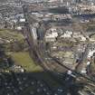
Oblique aerial view of the city showing the route of the M74 extension going through the Rutherglen area centred on Rutherglen railway station, taken from the W.
RCAHMS Aerial Photography Digital
12/2/2010
© Crown Copyright: HES

DP 075327
Oblique aerial view of the M74 extension going through the Rutherglen to Polamadie area centred on the Glenford engineering works, taken from the E.
RCAHMS Aerial Photography Digital
12/2/2010
© Crown Copyright: HES

DP 075330
Oblique aerial view of the power motive works looking SW towards Hampden Park stadium, taken from the NE.
RCAHMS Aerial Photography Digital
12/2/2010
© Crown Copyright: HES

DP 088400
Oblique aerial view of the city showing the route of the M74 extension going from the Polmadie area to Dalbeth bridge centred on the Power Motive Works, taken from the W.
RCAHMS Aerial Photography Digital
4/10/2010
© Crown Copyright: HES

DP 113653
General oblique aerial view of Glasgow centred on the M74 extension, taken from the W.
RCAHMS Aerial Photography Digital
14/6/2011
© Crown Copyright: HES

DP 063012
Oblique aerial view of the M74 extension centred on the junction with the M8 at the Kingston Bridge, taken from the WSW.
RCAHMS Aerial Photography Digital
2/8/2009
© Crown Copyright: HES

DP 063020
Oblique aerial view of the M74 extension looking towards the junction with the M8 at the Kingston Bridge, taken from the SSE.
RCAHMS Aerial Photography Digital
2/8/2009
© Crown Copyright: HES

DP 072197
Oblique aerial view centred on the motorway extension works, taken from the ESE.
RCAHMS Aerial Photography Digital
26/6/2009
© Crown Copyright: HES

DP 075325
General oblique aerial view of Glasgow showing the route of the M74 extension going through the Rutherglen to Polamadie area centred on Power Motive Works, taken from the E.
RCAHMS Aerial Photography Digital
12/2/2010
© Crown Copyright: HES

DP 075341
Oblique aerial view of the M74 extension going through the Polamadie area to the M74 centred on Gushetfaulds railway junction, taken from the ESE.
RCAHMS Aerial Photography Digital
12/2/2010
© Crown Copyright: HES

DP 088399
Oblique aerial view of the city showing the route of the M74 extension going through the Rutherglen area centred on Rutherglen railway station, taken from the N.
RCAHMS Aerial Photography Digital
4/10/2010
© Crown Copyright: HES

DP 088404
Oblique aerial view of the M74 extension going through the Port Eglinton area centred on the goods station, taken from the WSW.
RCAHMS Aerial Photography Digital
4/10/2010
© Crown Copyright: HES

DP 063016
Oblique aerial view of the M74 extension centred on the junction with the M8 at the Kingston Bridge, taken from the SSW.
RCAHMS Aerial Photography Digital
2/8/2009
© Crown Copyright: HES

DP 063022
Oblique aerial view of the M74 extension looking towards the junction with the M8 at the Kingston Bridge, taken from the SSE.
RCAHMS Aerial Photography Digital
2/8/2009
© Crown Copyright: HES

DP 071949
General view centred on the mtorway extension, taken from the SW.
RCAHMS Aerial Photography Digital
26/6/2009
© Crown Copyright: HES

DP 072223
General oblique aerial view centred on the steel works with the motorway extension works adjacent, taken from the ENE.
RCAHMS Aerial Photography Digital
26/6/2009
© Crown Copyright: HES

DP 075318
Oblique aerial view of the city showing the route of the M74 extension going through the Rutherglen area, taken from the WNW.
RCAHMS Aerial Photography Digital
12/2/2010
© Crown Copyright: HES

DP 075319
Oblique aerial view of the city showing the route of the M74 extension going through the Rutherglen area centred on Rutherglen railway station, taken from the W.
RCAHMS Aerial Photography Digital
12/2/2010
© Crown Copyright: HES

DP 088411
Oblique aerial view of the M74 extension going through the Port Eglinton area centred on junction with the M74 at the Kingston Bridge, taken from the S.
RCAHMS Aerial Photography Digital
4/10/2010
© Crown Copyright: HES

DP 088412
Oblique aerial view of the M74 extension going through the Port Eglinton area centred on junction with the M74 at the Kingston Bridge, taken from the SE.
RCAHMS Aerial Photography Digital
4/10/2010
© Crown Copyright: HES

DP 153782
General oblique aerial view of Glasgow centred on the M74 extension at Rutherglen, looking to the W.
RCAHMS Aerial Photography Digital
17/5/2013
© Crown Copyright: HES

DP 063011
Oblique aerial view of the M74 extension centred on the junction with the M8 at the Kingston Bridge, taken from the WSW.
RCAHMS Aerial Photography Digital
2/8/2009
© Crown Copyright: HES

DP 071987
Oblique aerial view centred on the railway station with the remains of another adjacent, taken from the W.
RCAHMS Aerial Photography Digital
26/6/2009
© Crown Copyright: HES

DP 072193
Oblique aerial view centred on the motorway extension works, taken from the SSE.
RCAHMS Aerial Photography Digital
26/6/2009
© Crown Copyright: HES

DP 072210
Oblique aerial view centred on the steel works, taken from the SSE.
RCAHMS Aerial Photography Digital
26/6/2009
© Crown Copyright: HES

DP 075337
Oblique aerial view of the M74 extension going through the Polamadie area to the M74 centred on Gushetfaulds railway junction, taken from the SSE.
RCAHMS Aerial Photography Digital
12/2/2010
© Crown Copyright: HES

DP 088403
Oblique aerial view of the city showing the route of the M74 extension going from the Ruthrglen area to Port Eglinton area looking W to Govan, taken from the E.
RCAHMS Aerial Photography Digital
4/10/2010
© Crown Copyright: HES

DP 088406
Oblique aerial view of the M74 extension meeting the M74 motorway at the Kingston bridge centred on the engine works, taken from the SE.
RCAHMS Aerial Photography Digital
4/10/2010
© Crown Copyright: HES

DP 063014
Oblique aerial view of the M74 extension centred on the junction with the M8 at the Kingston Bridge, taken from the SSW.
RCAHMS Aerial Photography Digital
2/8/2009
© Crown Copyright: HES

DP 063015
Oblique aerial view of the M74 extension centred on the junction with the M8 at the Kingston Bridge, taken from the SSW.
RCAHMS Aerial Photography Digital
2/8/2009
© Crown Copyright: HES

DP 063018
Oblique aerial view of the M74 extension centred on the junction with the M8 at the Kingston Bridge, taken from the S.
RCAHMS Aerial Photography Digital
2/8/2009
© Crown Copyright: HES

DP 063019
Oblique aerial view of the M74 extension centred on the junction with the M8 at the Kingston Bridge, taken from the S.
RCAHMS Aerial Photography Digital
2/8/2009
© Crown Copyright: HES

DP 075314
General oblique aerial view of Glasgow showing the route of the M74 extension, taken from the E.
RCAHMS Aerial Photography Digital
12/2/2010
© Crown Copyright: HES

DP 075316
General oblique aerial view of Glasgow showing the route of the M74 extension going through the Rutherglen area, taken from the E.
RCAHMS Aerial Photography Digital
12/2/2010
© Crown Copyright: HES

DP 075320
Oblique aerial view of the city showing the route of the M74 extension going through the Rutherglen area centred on Rutherglen railway station, taken from the W.
RCAHMS Aerial Photography Digital
12/2/2010
© Crown Copyright: HES

DP 075346
Oblique aerial view of the M74 extension going through the Port Eglinton area to the M74 centred on the Eglinton Street goods station, taken from the WSW.
RCAHMS Aerial Photography Digital
12/2/2010
© Crown Copyright: HES

DP 088407
Oblique aerial view of the M74 extension going through the Port Eglinton area centred on the engine works, taken from the NE.
RCAHMS Aerial Photography Digital
4/10/2010
© Crown Copyright: HES

DP 088408
Oblique aerial view of the city showing the route of the M74 extension going from the Port Eglinton area to Polamdie area centred on the Power Motive Works looking E, taken from the W.
RCAHMS Aerial Photography Digital
4/10/2010
© Crown Copyright: HES

DP 063017
Oblique aerial view of the M74 extension centred on the junction with the M8 at the Kingston Bridge, taken from the S.
RCAHMS Aerial Photography Digital
2/8/2009
© Crown Copyright: HES

DP 071956
Oblique aerial view centred on the motorway extension with a small industrial estate adjacent, taken from the SE.
RCAHMS Aerial Photography Digital
26/6/2009
© Crown Copyright: HES

DP 071990
General oblique aerial view centred on the motorway extension works, taken from the SW.
RCAHMS Aerial Photography Digital
26/6/2009
© Crown Copyright: HES

DP 075326
General oblique aerial view of Glasgow showing the route of the M74 extension going through the Rutherglen to Polamadie area centred on Power Motive Works, taken from the E.
RCAHMS Aerial Photography Digital
12/2/2010
© Crown Copyright: HES

DP 075340
Oblique aerial view of the M74 extension going through the Polamadie area to the M74 centred on Gushetfaulds railway junction, taken from the SE.
RCAHMS Aerial Photography Digital
12/2/2010
© Crown Copyright: HES

DP 075345
Oblique aerial view of the M74 extension going through the Port Eglinton area to the M74 centred on the Eglinton Street goods station, taken from the WSW.
RCAHMS Aerial Photography Digital
12/2/2010
© Crown Copyright: HES

DP 075348
Oblique aerial view of the M74 extension going through the Port Eglinton area to the M74 centred on the Eglinton Street goods station, taken from the SW.
RCAHMS Aerial Photography Digital
12/2/2010
© Crown Copyright: HES

DP 088402
Oblique aerial view of the city showing the route of the M74 extension going from the Rutherglen area to the Port Eglinton area, taken from the SE.
RCAHMS Aerial Photography Digital
4/10/2010
© Crown Copyright: HES

DP 088405
Oblique aerial view of the M74 extension going through the Port Eglinton area centred on the engine works, taken from the SSW.
RCAHMS Aerial Photography Digital
4/10/2010
© Crown Copyright: HES

DP 088409
Oblique aerial view of the city showing the route of the M74 extension going from the Port Eglinton area to Polamdie area centred on the Power Motive Works looking E to the Shettleston area, taken from the W.
RCAHMS Aerial Photography Digital
4/10/2010
© Crown Copyright: HES

DP 088410
Oblique aerial view of the M74 extension going through the Port eglinton area centred on the goods station, taken from the WNW.
RCAHMS Aerial Photography Digital
4/10/2010
© Crown Copyright: HES

DP 071965
Oblique aerial view centred on the industrial estate with the M74 extension work adjacent, taken from the SW.
RCAHMS Aerial Photography Digital
26/6/2009
© Crown Copyright: HES

DP 071984
Oblique aerial view centred on the railway station, taken from the N.
RCAHMS Aerial Photography Digital
26/6/2009
© Crown Copyright: HES

DP 071985
Oblique aerial view centred on the railway station, taken from the NW.
RCAHMS Aerial Photography Digital
26/6/2009
© Crown Copyright: HES

DP 071986
Oblique aerial view centred on the railway station, taken from the WNW.
RCAHMS Aerial Photography Digital
26/6/2009
© Crown Copyright: HES

DP 075344
Oblique aerial view of the M74 extension going through the Port Eglinton area to the M74 centred on the grain and hay store, taken from the NW.
RCAHMS Aerial Photography Digital
12/2/2010
© Crown Copyright: HES

DP 075347
Oblique aerial view of the M74 extension going through the Port Eglinton area to the M74 centred on the Kilbirnie Street bridge, taken from the W.
RCAHMS Aerial Photography Digital
12/2/2010
© Crown Copyright: HES


- Council South Lanarkshire
- Parish Rutherglen (South Lanarkshire)
- Former Region Strathclyde
- Former District City Of Glasgow
- Former County Lanarkshire
NS66SW 990.00 from 64227 62338 to 60000 62478
NS66SW 990.01 c.NS 6343 6246 Road Bridge
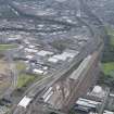
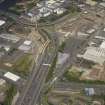
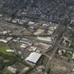
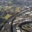
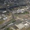
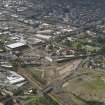
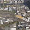
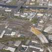
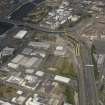
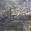
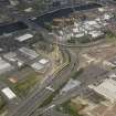
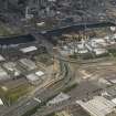
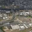
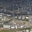
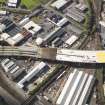
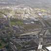
Motorway extension from the present end of the M74 motorway to the M8. Construction work began in 2009.
Information from RCAHMS (DE), February 2010

