
Ditch


Farmstead (Period Unassigned)
Site Name Ditch
Classification Farmstead (Period Unassigned)
Alternative Name(s) Bishopton, Royal Ordnance Factory
Canmore ID 302099
Site Number NS47SW 151
NGR NS 43240 70421
Datum OSGB36 - NGR
Permalink http://canmore.org.uk/site/302099


- Council Renfrewshire
- Parish Erskine
- Former Region Strathclyde
- Former District Renfrew
- Former County Renfrewshire
NS47SW 151 centred 43240 70421
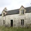
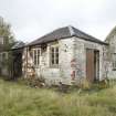
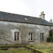
The farmstead of Ditch is situated amongst several Royal Ordnance factory (NS47SW 149.00), buildings about 448m W of the main E gate.
Built of stone with slated roof the farmstead is almost T-shaped in plan with an additional range on the S side of a courtyard. The farmhouse is on the W side with few remaining features inside, having been utlised by the Ordnance Factory. The buildings are still roofed though in a derelict state as they are no longer used by the factory.
The farmstead is depicted as roofed on the 1st Edition of the 6-inch map (Renfrewshire, 1863, sheet vii), which shows that at that date there were three buildings. In addition the map shows a small garden or orchard on the SW side. The Object Name Book of the Ordnance Survey (ONB) describes the farm as 'A good farm house having office and land attached. The property of J H Maxwell Esq.' (Name Book 1857).
Visited by RCAHMS (DE), October 2009

