
Tiree Airfield, Domestic Site, Site 5


Military Camp (20th Century)
Site Name Tiree Airfield, Domestic Site, Site 5
Classification Military Camp (20th Century)
Canmore ID 301965
Site Number NL94SE 54.02
NGR NL 99961 43750
NGR Description Centred NL 99961 43750
Datum OSGB36 - NGR
Permalink http://canmore.org.uk/site/301965


- Council Argyll And Bute
- Parish Tiree
- Former Region Strathclyde
- Former District Argyll And Bute
- Former County Argyll
NL94SE 54.02 centred 99961 43750
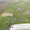
Little survives apart from concrete hut bases of a military camp identified from oblique aerial views (RCAHMSAP 2009). The camp was probably built to accommodate service personnel based at the airfield and is situated on the machair immediately N of the Traig Bhagh at the W end of the beach. The camp consisted of over forty huts, mainly of the Nissen type.
The huts and buildings are visible on RAF WW II vertical air photographs (NLA 21, frames 603-605, flown 19 November 1941). The camp was expanded following the date of the WW II vertical air photography with additional huts to the N of the original group.
The Reef Terrace and Sruthan Terrace modern housing estates (NL94SE 54 and NL94SE 55 ) have been built on part of the site.
Information from RCAHMS (DE), January 2010
Note (6 October 2020)
At least fourteen Blast Shelters have been identified on a RAF vertical air photograph 106G/Scot/UK/0034 3337 (flown 27 April 1946) within the technical area. Five blast shelters are visible on modern air photographs and OS mapping.
Information from HES (AKK) 6 October 2020.

