
St Kilda, Hirta, The Cambir


Wall(S) (Period Unassigned)
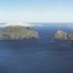
Site Name St Kilda, Hirta, The Cambir
Classification Wall(S) (Period Unassigned)
Canmore ID 301253
Site Number NA00SE 32
NGR NA 07734 00811
NGR Description from NA 07707 00795 to 07759 00831
Datum OSGB36 - NGR
Permalink http://canmore.org.uk/site/301253


- Council Western Isles
- Parish Harris
- Former Region Western Isles Islands Area
- Former District Western Isles
- Former County Inverness-shire
Field Visit (4 September 2009)
A ruinous wall runs from NE to SW across the neck of land leading onto The Cambir (from NA07707 00795 to 07759 00831); the break towards its NE end is probably an original entrance. To the SE, there are traces of another wall on the same alignment, though this is discontinuous and may be earlier. Further stretches of ruinous walling are visible around The Cambir.
Visited by RCAHMS (ARG) 4 September 2009

