
St Kilda, Hirta, Village Bay, Blackhouse M


Blackhouse (19th Century)
Site Name St Kilda, Hirta, Village Bay, Blackhouse M
Classification Blackhouse (19th Century)
Canmore ID 300974
Site Number NF19NW 21.47
NGR NF 10059 99343
Datum OSGB36 - NGR
Permalink http://canmore.org.uk/site/300974


- Council Western Isles
- Parish Harris
- Former Region Western Isles Islands Area
- Former District Western Isles
- Former County Inverness-shire
Publication Account (1988)
NF19NW 21.47 10059 99343
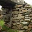
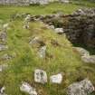
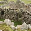
Along with Blackhouses N and O, this group of drystone buildings lies end-on to the street, occupying a site between Houses 10 and 11 in the area to the W of the main consumption dyke. Blackhouses M and N are contiguous, sharing a common side-wall. It is clear from Sharbau's plan that in 1858 these houses were used by Donald MacQueen and John Gillies. House 10 nearby, which replaced another blackhouse in this group continued to be occupied by the MacQueens, and House 11 by the Gillies household.
Blackhouse M measures internally 5.64m by 2.95m within walls up to 1.7m thick. Externally, the walls are battered and the corners rounded. At the N end the external wall-face is low because the building is set in to a slope, but the line of an outer face continues at a lower level, curving into a mound. On the NW corner of this mound is a small cleit-like structure, roofed with timber and turf, now mostly collapsed. In the E side-wall of the main building there is a window and doorway, the doorway-opening retaining the post of a wooden door-frame. Inside, the S angles are rounded and at the squared NE angle the N end-wall is bonded only in its upper courses. A drain, not visible inside, empties on to the street from the centre of the S end-wall. Another drain runs under the flagstones on the E side, and then below the street.
G P Stell and M Harman 1988.

