|
Manuscripts |
MS 2256 |
Records of CFA Archaeology Ltd, archaeologists, Musselburgh, East Lothian, Scotland |
Report: Coastal Zone Assessment Survey. Firth of Clyde and Isle of Bute. CFA Archaeology Ltd, 2004.
Written by M Cressey and M Johnson |
8/2004 |
Item Level |
|
 |
On-line Digital Images |
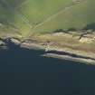
DP 057281 |
RCAHMS Aerial Photography Digital |
Oblique aerial view centred on the jetty, taken from the SW. |
31/10/2008 |
Item Level |
|
 |
On-line Digital Images |
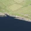
DP 144030 |
RCAHMS Aerial Photography Digital |
Oblique aerial view of the jetty, looking NNE. |
7/8/2012 |
Item Level |
|
|
Manuscripts |
MS 7154/1 |
Records of CFA Archaeology Ltd, archaeologists, Musselburgh, East Lothian, Scotland |
Coastal Survey Form: Coastal Zone Assessment Survey. Firth of Clyde and Isle of Bute. CFA Archaeology Ltd, 2004.
Written by M Cressey and M Johnson |
8/2004 |
Item Level |
|
|
Manuscripts |
MS 7154/2 |
Records of CFA Archaeology Ltd, archaeologists, Musselburgh, East Lothian, Scotland |
Coastal Survey Form: Coastal Zone Assessment Survey. Firth of Clyde and Isle of Bute. CFA Archaeology Ltd, 2004.
Written by M Cressey and M Johnson |
12/2003 |
Item Level |
|
|
Manuscripts |
MS 7803 |
Association of Certificated Field Archaeologists |
Report: 'The Coastal Archaeology Record Enhancement Survey (CARES): an archaeological survey of the coastline of Bute by the Association of Certificated Field Archaeologists in association with the Discover Bute Landscape Partnership Scheme. Part 2, 2011-12: Stravannan Bay to Kilchattan Bay' |
2011 |
Item Level |
|


