
Following the launch of trove.scot in February 2025 we are now planning the retiral of some of our webservices. Canmore will be switched off on 24th June 2025. Information about the closure can be found on the HES website: Retiral of HES web services | Historic Environment Scotland
Ellon, Wateridgemuir


Farmstead (Period Unassigned)
Site Name Ellon, Wateridgemuir
Classification Farmstead (Period Unassigned)
Canmore ID 300614
Site Number NJ92NE 128
NGR NJ 95369 26419
Datum OSGB36 - NGR
Permalink http://canmore.org.uk/site/300614


- Council Aberdeenshire
- Parish Logie Buchan
- Former Region Grampian
- Former District Gordon
- Former County Aberdeenshire
NJ92NE 128.00 95369 26419
Note (15 August 2010)
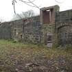
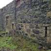
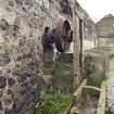
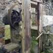
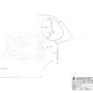
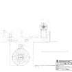
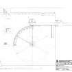
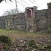
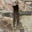
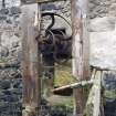
The steading at Wateridgemuir is located 4 km S of Ellon (see DC 48442) on what was the Esslemont Estate. The steading appears to have been completely rebuilt after 1852 (Wolrige-Gordon Papers, Plan of Wateridgemuir Farm, Ellon, MS Acc 040, Box 5, Bundle 5, 1824 (farms) /1852 (farmland), University of Aberdeen, Special Libraries and Archives), the altered form of the buildings and the absence of a mill pond indicating that change took place in the mid 19th century. It is a large E plan farm steading comprising a cart shed and granary on the main NW range with threshing barn and cow sheds forming the three perpendicular ranges. To the NE of the steading survives the remains of a large overshot metal waterwheel (4.5m diameter x 1m wide) in an underground cavern which is fed by a lade from the nearby millpond, evidence of which still survives.
The site is depicted on the Ordnance Survey 1st edition 25-inch map (Aberdeenshire, 1867-68, sheet XLVII.7 and XLVII.11) as a roofed ‘E’ plan steading with a mill pond to the N. The steading sits on a level site 35m above OD and was photographed by RCAHMS in advance of conversion to dwellings.
Visited by RCAHMS (MMD), 15 August 2007 and October 2007

