
Machrihanish Airfield, Domestic Site, Us Service Personnel


Building(S) (20th Century), House(S) (20th Century), Hut(S) (20th Century), Squash Court (20th Century)
Site Name Machrihanish Airfield, Domestic Site, Us Service Personnel
Classification Building(S) (20th Century), House(S) (20th Century), Hut(S) (20th Century), Squash Court (20th Century)
Canmore ID 300504
Site Number NR62SE 28.05
NGR NR 66384 23601
NGR Description Centred NR 66384 23601
Datum OSGB36 - NGR
Permalink http://canmore.org.uk/site/300504


- Council Argyll And Bute
- Parish Campbeltown
- Former Region Strathclyde
- Former District Argyll And Bute
- Former County Argyll
NR62SE 28.05 centred 66384 23601
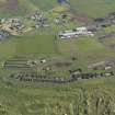
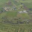
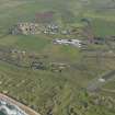
Situated at the N end of the airfield immediately S of Clochkeil farmsteading within a separate wire fenced enclosure is a group of brick built accommodation blocks and huts. Most are flat roofed and now all derelict. Built in 1970's for United States service personnel. In total about 16 buildings. The individual huts are of pitched roofed type. Also found within the enclosure are the officer's mess and a hospital with ambulanec bay.
Within this enclosure is the original squash court built to wartime design, which would have formerly stood in the main administrative area (NR62SE 28.05).
Visited by RCAHMS (DE, JM), 24 September 2009

