
Pricing Change
New pricing for orders of material from this site will come into place shortly. Charges for supply of digital images, digitisation on demand, prints and licensing will be altered.
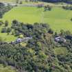
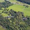
Ardgowan House


Walled Garden (Period Unknown)
Site Name Ardgowan House
Classification Walled Garden (Period Unknown)
Alternative Name(s) Ardgowan House Policies
Canmore ID 300343
Site Number NS27SW 20.05
NGR NS 20637 72832
Datum OSGB36 - NGR
Permalink http://canmore.org.uk/site/300343


- Council Inverclyde
- Parish Inverkip
- Former Region Strathclyde
- Former District Inverclyde
- Former County Renfrewshire
NS27SW 20.05 20637 72832
The feature at this location was formerly entered as the Formal Garden and Sundial, whose map reference has now been amended. See NS27SW 20.03.
First and second edition maps indicate that there was a sundial in the Walled Garden, but the sundials recorded by Somerville in 1982 were both located 'in the rose garden immediately behind the mansion house' (MS 5741/5/8). Photographic evidence shows that this area can be identified with the Formal Garden (NS27SW 20.03).
(Anne Cassells, 10 September 2009).

