
Tankerness, Hall Of Tankerness, Fishing Station, Salt Warehouse


Fishing Station (19th Century)
Site Name Tankerness, Hall Of Tankerness, Fishing Station, Salt Warehouse
Classification Fishing Station (19th Century)
Canmore ID 3003
Site Number HY50NW 42
NGR HY 52261 08620
Datum OSGB36 - NGR
Permalink http://canmore.org.uk/site/3003


- Council Orkney Islands
- Parish St Andrews And Deerness
- Former Region Orkney Islands Area
- Former District Orkney
- Former County Orkney
HY50NW 42.00 52261 08620
HY50NW 42.01 HY 52246 08624 Bothy
HY50NW 42.02 HY 52334 08616 Curing House
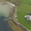
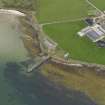
HY50NW 42.03 HY 52294 08559 Pier
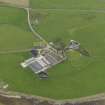
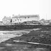
At the shore below the Hall there is an interesting fishing-station complex, where herring-curing was started in 1833: a deep-water pier, two smaller jetties, a slipway and boathouse; and good buildings, including a salt warehouse and a curing-house. Set as a bollard at the end of the pier is a gun from the Ness Battery (HY50NW 5 and HY50NW 55 ).
NSA 1845; Bichan 1977; Paterson 1977; RCAHMS 1987, visited April 1979.
The fishing station, comprising three roofed buildings, one unroofed building and one enclosure is depicted on the 1st edition of the OS 6-inch map (Orkney and Shetland (Orkney) 1882, sheet cix) as well as three piers.
Two roofed buildings, one enclosure and two piers are shown on the current edition of the OS 1:10000 map (1971).
Information from RCAHMS (AKK), 29 November 2000.

