
Pricing Change
New pricing for orders of material from this site will come into place shortly. Charges for supply of digital images, digitisation on demand, prints and licensing will be altered.
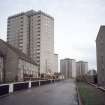
Aberdeen, Brierfield Terrace


Tower Block(S) (20th Century)
Site Name Aberdeen, Brierfield Terrace
Classification Tower Block(S) (20th Century)
Alternative Name(s) Aberdeen, Cornhill-stockethill, Section I
Canmore ID 300067
Site Number NJ90NW 2646
NGR NJ 91615 07754
Datum OSGB36 - NGR
Permalink http://canmore.org.uk/site/300067


- Council Aberdeen, City Of
- Parish Aberdeen
- Former Region Grampian
- Former District City Of Aberdeen
- Former County Aberdeenshire
Construction (1966 - 21 December 1967)
A development of three multi-storey blocks built as public housing development 'Section I' in the Cornhill-Stockethill area for Aberdeen Borough Council. The seventeen-storey block, Cornhill Court, contains 100 dwellings. The two-sixteen storey blocks, Rosehill Court and Cairncry Court, contain 188 dwellings in total. The contractor for the development was George Wimpey & Co. Ltd. Construction began in 1966.
Glendinning and Methusius 1994
Photographic Record (August 1983)
Photos taken br Dr Miles Glendinning for research purposes.
Photographic Record (January 1983)
Photos taken by Dr Miles Glendinning for research purposes.

