
Edinburgh, Greendykes Rd


Path (Period Unassigned), Tower Block(S) (20th Century)
Site Name Edinburgh, Greendykes Rd
Classification Path (Period Unassigned), Tower Block(S) (20th Century)
Alternative Name(s) Edinburgh, Greendykes 3 Temporay Housing Area (Tha)
Canmore ID 299859
Site Number NT27SE 6026
NGR NT 29899 71093
Datum OSGB36 - NGR
Permalink http://canmore.org.uk/site/299859

- Council Edinburgh, City Of
- Parish Edinburgh (Edinburgh, City Of)
- Former Region Lothian
- Former District City Of Edinburgh
- Former County Midlothian
Commission And Contract (1964)
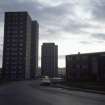
A development of two fifteen-storey tower blocks built as a phase of public housing in the Greendykes area of Niddrie. The blocks were constructed by Edinburgh Borough Council. They contain a total of 172 dwellings. Construction was approved by committee in 1964. The contractor for the development was Crudens Ltd.
Glendinning and Methusius 1994
Photographic Record (1985)
Photo taken by Dr Miles Glendinning for research purposes.
Archaeological Evaluation (15 January 2004)
An Environmental Impact Assesment was carried out by Kirkdale Archaeology in January 2004 on behalf of ERM (Environmental Resource Managment). The survey covered the grounds around the Greendykes Estate, including the Niddrie Burn and the Niddrie Standing stone.
G Ewart
Sponsor: ERM
Kirkdale Archaeology
Watching Brief (19 November 2012)
NT 299 711 A watching brief was carried out on 19 November 2012 during the reinstatement of an access track to a new energy centre within the former policies of Niddrie House. The course of a path, marked on the 1st Edition OS map, was located and its surface found to be made up of broken paving slabs and crushed bricks.
Archive: RCAHMS
Funder: City of Edinburgh Council
Derek Hall, 2013
(Source: DES)

