
Pricing Change
New pricing for orders of material from this site will come into place shortly. Charges for supply of digital images, digitisation on demand, prints and licensing will be altered.
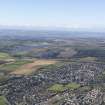
Kelty, General


General View (Period Unassigned), Village (Period Unassigned)
Site Name Kelty, General
Classification General View (Period Unassigned), Village (Period Unassigned)
Alternative Name(s) Oakfield
Canmore ID 299646
Site Number NT19SW 89
NGR NT 14277 94395
NGR Description Centred NT 14277 94395
Datum OSGB36 - NGR
Permalink http://canmore.org.uk/site/299646


- Council Fife
- Parish Beath
- Former Region Fife
- Former District Dunfermline
- Former County Fife
NT19SW 89 centred 14277 94395
'Oakfield' on the 1st Edition of the OS 6-inch map (Ffe & Kinross, 1854) shown at the crossroads between Oakfield Street and Cocklaw Street. Kelty shown further N in an area annotated as' Kelty Colliery'. Oakfield was subsumed into Kelty between the date of the 1st Edition OS 6-inch map (Fife & Kinross, 1856) and the 2nd Edition of 1899-1900.
Information from RCAHMS (DE), July 2009

